|
Digital Typhoon: Heavy Rains in Hokkaido Prefecture (September 2014) - Case Studies of Heavy Rains |
|
|
1. Heavy Rains in Hokkaido Prefecture (September 2014)
Data related to heavy rains in Hokkaido prefecture on September, 2014, is summarized here.
Radar Imagery
Real-time weather radar images are cropped for the region of heavy rains, and make them available as time-series images.
- Radar Imagery (Zoom 8)
- Radar Imagery (Zoom 9)
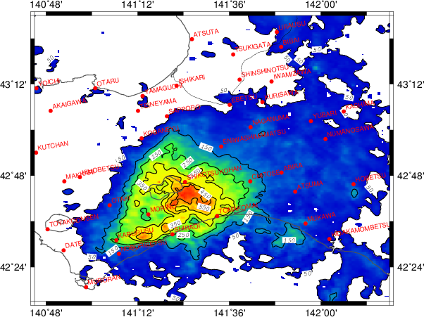
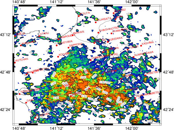
The images below illustrates the spatial distribution of radar observations from JST 09, September 9, 2014. These observation values, however, were not calibrated by ground-based observations, so it may not be accurate as the absolute value. It should be used as relative values illustrating spatial distribution.
| 10-min radar cumulative precipitation (mm) |
10-min radar maximum precipitation (mm) |
 |
 |
AMeDAS Data
- AMeDAS: SAPPORO (SAPPORO SHI CHUO KU, HOKKAIDO)
- AMeDAS: SHIKOTSUKOHAN (CHITOSE SHI, HOKKAIDO)
- AMeDAS: CHITOSE (CHITOSE SHI, HOKKAIDO)
- AMeDAS: ABIRA (YUFUTSU GUN ABIRA CHO, HOKKAIDO)
- AMeDAS: MORINO (SHIRAOI GUN SHIRAOI CHO, HOKKAIDO)
- AMeDAS: TOMAKOMAI (TOMAKOMAI SHI, HOKKAIDO)
- AMeDAS: KARURUSU (NOBORIBETSU SHI, HOKKAIDO)
Distribution of AMeDAS Precipitation
- Heavy Rain in September 2014
Social Media (Twitter)
-
Futtekitter (in Japanese)