|
Digital Typhoon: Heavy Rains in Kanto Region (September 2015) - Case Studies of Heavy Rains |
|
|
1. Heavy Rains in Kanto Region (September 2015)
This page summarizes weather data related to heavy rains in Kanto Region on September, 2015, caused by Typhoon 201518. Data for the same period is also available at Heavy Rains in Tohoku Region (September 2015).
Radar Imagery
Real-time weather radar images are cropped for the region of heavy rains, and make them available as time-series images.
- Radar Imagery (Zoom 8)
- MP4 Animation
- GIF Animation
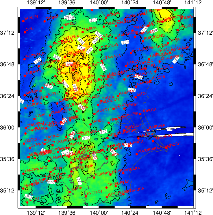
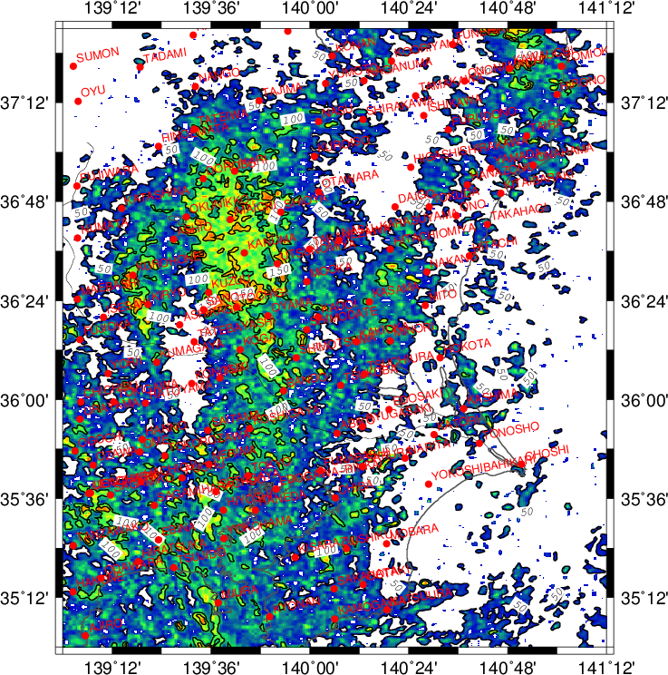
The images below illustrates the spatial distribution of radar observations from JST 00, September 9, 2015. These observation values, however, were not calibrated by ground-based observations, so it may not be accurate as the absolute value. It should be used as relative values illustrating spatial distribution.
| 10-min radar cumulative precipitation (mm) |
10-min radar maximum precipitation (mm) |
 |
 |
AMeDAS Data
- AMeDAS: IKARI (NIKKO SHI, TOCHIGI KEN)
- AMeDAS: DOROBU (NIKKO SHI, TOCHIGI KEN)
- AMeDAS: IMAICHI (NIKKO SHI, TOCHIGI KEN)
- AMeDAS: OKUNIKKO (NIKKO SHI, TOCHIGI KEN)
- AMeDAS: KANUMA (KANUMA SHI, TOCHIGI KEN)
- AMeDAS: UTSUNOMIYA (UTSUNOMIYA SHI, TOCHIGI KEN)
- AMeDAS: TOCHIGI (TOCHIGI SHI, TOCHIGI KEN)
- AMeDAS: OYAMA (OYAMA SHI, TOCHIGI KEN)
- AMeDAS: KOGA (KOGA SHI, IBARAKI KEN)
- AMeDAS: KOSHIGAYA (KOSHIGAYA SHI, SAITAMA KEN)
Distribution of AMeDAS Precipitation
- Heavy Rain in September 2015