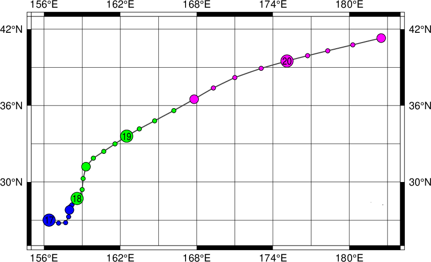
|
Year
|
Month
|
Day
|
Hour
|
Lat.
|
Long.
|
Wind (kt)
|
Gust (kt)
|
Direc. of Major Storm Axis
|
Radius of Major Storm Axis (nm)
|
Radius of Minor Storm Axis (nm)
|
Direc. of Major Gale Axis
|
Radius of Major Gale Axis (nm)
|
Radius of Minor Gale Axis (nm)
|
Image
|
| 2022 |
10 |
17 |
00 |
27.0 |
156.4 |
0 |
0 |
- |
- |
- |
- |
- |
- |
Image |
| 2022 |
10 |
17 |
06 |
26.8 |
157.7 |
0 |
0 |
- |
- |
- |
- |
- |
- |
Image |
| 2022 |
10 |
17 |
12 |
27.8 |
158.0 |
0 |
0 |
- |
- |
- |
- |
- |
- |
Image |
| 2022 |
10 |
17 |
18 |
28.2 |
158.2 |
0 |
0 |
- |
- |
- |
- |
- |
- |
Image |
| 2022 |
10 |
18 |
00 |
28.7 |
158.6 |
35 |
0 |
- |
- |
- |
SE |
120 |
90 |
Image |
| 2022 |
10 |
18 |
06 |
29.4 |
159.0 |
35 |
0 |
- |
- |
- |
SE |
120 |
90 |
Image |
| 2022 |
10 |
18 |
12 |
31.2 |
159.3 |
35 |
0 |
- |
- |
- |
SE |
150 |
90 |
Image |
| 2022 |
10 |
18 |
18 |
32.4 |
160.7 |
35 |
0 |
- |
- |
- |
SE |
150 |
90 |
Image |
| 2022 |
10 |
19 |
00 |
33.6 |
162.5 |
35 |
0 |
- |
- |
- |
SE |
150 |
90 |
Image |
| 2022 |
10 |
19 |
06 |
34.8 |
164.7 |
35 |
0 |
- |
- |
- |
SE |
120 |
90 |
Image |
| 2022 |
10 |
19 |
12 |
36.5 |
167.8 |
0 |
0 |
- |
- |
- |
- |
- |
- |
Image |
| 2022 |
10 |
19 |
18 |
38.2 |
171.0 |
0 |
0 |
- |
- |
- |
- |
- |
- |
Image |
| 2022 |
10 |
20 |
00 |
39.5 |
175.1 |
0 |
0 |
- |
- |
- |
- |
- |
- |
Image |
| 2022 |
10 |
20 |
06 |
40.3 |
178.3 |
0 |
0 |
- |
- |
- |
- |
- |
- |
Image |
| 2022 |
10 |
20 |
12 |
41.3 |
182.5 |
0 |
0 |
- |
- |
- |
- |
- |
- |
Image |
|

