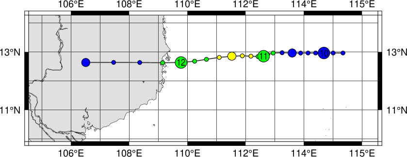
|
Year
|
Month
|
Day
|
Hour
|
Lat.
|
Long.
|
Pressure (hPa)
|
Wind (kt)
|
Class
|
Image
|
Chart
|
Warning
|
| 1990 |
11 |
9 |
18 |
12.8 |
114.9 |
1004 |
0 |
2 |
Image |
Chart |
--
|
| 1990 |
11 |
10 |
00 |
12.8 |
114.3 |
1004 |
0 |
2 |
Image |
Chart |
--
|
| 1990 |
11 |
10 |
06 |
12.8 |
113.8 |
1004 |
0 |
2 |
Image |
Chart |
--
|
| 1990 |
11 |
10 |
12 |
12.8 |
113.3 |
1002 |
0 |
2 |
Image |
Chart |
--
|
| 1990 |
11 |
10 |
18 |
12.8 |
112.7 |
998 |
35 |
3 |
Image |
Chart |
--
|
| 1990 |
11 |
11 |
00 |
12.7 |
112.4 |
994 |
40 |
3 |
Image |
Chart |
--
|
| 1990 |
11 |
11 |
06 |
12.7 |
112.0 |
990 |
50 |
4 |
Image |
Chart |
--
|
| 1990 |
11 |
11 |
12 |
12.7 |
111.4 |
990 |
50 |
4 |
Image |
Chart |
--
|
| 1990 |
11 |
11 |
18 |
12.6 |
110.6 |
994 |
40 |
3 |
Image |
Chart |
--
|
| 1990 |
11 |
12 |
00 |
12.5 |
109.8 |
998 |
35 |
3 |
Image |
Chart |
--
|
| 1990 |
11 |
12 |
06 |
12.5 |
108.5 |
1002 |
0 |
2 |
Image |
Chart |
--
|
| 1990 |
11 |
12 |
12 |
12.5 |
106.8 |
1006 |
0 |
2 |
Image |
Chart |
--
|
|

