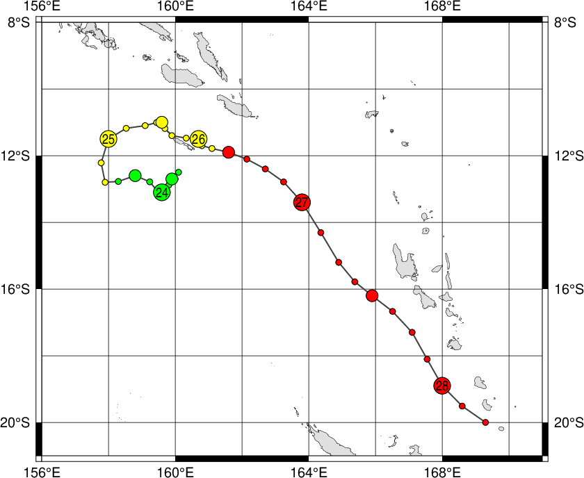
|
Year
|
Month
|
Day
|
Hour
|
Lat.
|
Long.
|
Pressure (hPa)
|
Wind (kt)
|
Class
|
Image
|
Chart
|
Warning
|
| 1996 |
12 |
23 |
06 |
-12.5 |
160.1 |
996 |
35 |
3 |
Image |
--
|
--
|
| 1996 |
12 |
23 |
12 |
-12.7 |
159.9 |
996 |
35 |
3 |
Image |
--
|
--
|
| 1996 |
12 |
23 |
18 |
-12.7 |
160.0 |
995 |
35 |
3 |
Image |
--
|
--
|
| 1996 |
12 |
24 |
00 |
-13.1 |
159.6 |
995 |
35 |
3 |
Image |
--
|
--
|
| 1996 |
12 |
24 |
06 |
-13.1 |
159.5 |
995 |
40 |
3 |
Image |
--
|
--
|
| 1996 |
12 |
24 |
12 |
-12.6 |
158.8 |
995 |
40 |
3 |
Image |
--
|
--
|
| 1996 |
12 |
24 |
18 |
-12.8 |
157.9 |
985 |
50 |
4 |
Image |
--
|
--
|
| 1996 |
12 |
25 |
00 |
-11.5 |
158.0 |
975 |
55 |
4 |
Image |
--
|
--
|
| 1996 |
12 |
25 |
06 |
-11.1 |
159.1 |
975 |
55 |
4 |
Image |
--
|
--
|
| 1996 |
12 |
25 |
12 |
-11.0 |
159.6 |
975 |
55 |
4 |
Image |
--
|
--
|
| 1996 |
12 |
25 |
18 |
-11.4 |
159.9 |
975 |
55 |
4 |
Image |
--
|
--
|
| 1996 |
12 |
26 |
00 |
-11.5 |
160.7 |
975 |
60 |
4 |
Image |
--
|
--
|
| 1996 |
12 |
26 |
06 |
-11.7 |
160.8 |
975 |
60 |
4 |
Image |
--
|
--
|
| 1996 |
12 |
26 |
12 |
-11.9 |
161.6 |
975 |
65 |
5 |
Image |
--
|
--
|
| 1996 |
12 |
26 |
18 |
-12.4 |
162.7 |
970 |
70 |
5 |
Image |
--
|
--
|
| 1996 |
12 |
27 |
00 |
-13.4 |
163.8 |
970 |
70 |
5 |
Image |
--
|
--
|
| 1996 |
12 |
27 |
06 |
-15.2 |
164.9 |
970 |
70 |
5 |
Image |
--
|
--
|
| 1996 |
12 |
27 |
12 |
-16.2 |
165.9 |
970 |
70 |
5 |
Image |
--
|
--
|
| 1996 |
12 |
27 |
18 |
-17.3 |
167.1 |
960 |
80 |
5 |
Image |
--
|
--
|
| 1996 |
12 |
28 |
00 |
-18.9 |
168.0 |
955 |
85 |
5 |
Image |
--
|
--
|
| 1996 |
12 |
28 |
06 |
-20.0 |
169.3 |
955 |
85 |
5 |
Image |
--
|
--
|
|

