| Infrared 1 | Infrared 2 |
|---|---|
 |
 |
| Infrared 3 | Infrared 4 |
 |
 |
| ||||||||||||
| ||||||||||||
|
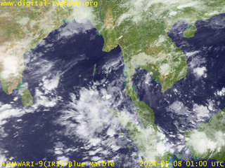
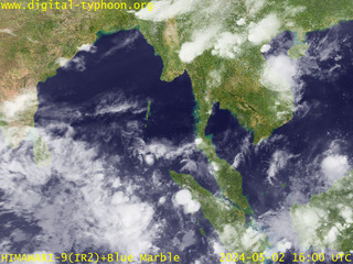
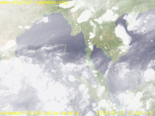
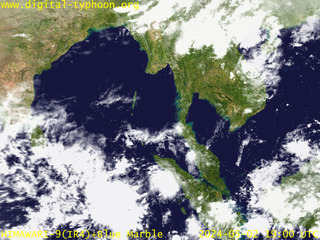
This page provides satellite images around South East Asia to South Asia, including Thailand, Laos, Cambodia, Vietnam, Malaysia, Singapore, Indonesia, Myanmar, Bangladesh, India, Sri Lanka.
| Infrared 1 | Infrared 2 |
|---|---|
|
|
| Infrared 3 | Infrared 4 |
|
|
In the northern Indian Ocean, Bay of Bengal, cyclones give large impacts on India and Bangladesh. Information about cyclones can be found on the following page.
This page was originally started as a response to Indian Ocean Earthquake. On December 26 2004 at 00:58:53 UTC, 2004 Indian Ocean earthquake caused devastating tsunamis exceeding the height of 30 meters at maximum, which resulted in nearly 300,000 people who are either killed or missing, and a few million people are now suffering from the disasters of an unprecedented scale. Furthermore, tsunami-affected areas are more vulnerable to natural hazards than before, and it is concerned that heavy rainfall and cyclones may cause another disaster. This situation motivated me to start a special page that provides meteorological satellite images of the northern Indian Ocean area for the monitoring of weather in this area.
Meteorological satellite images in this page is an infrared (gray-scale) satellite image observed by GOES-9, which is then overlayed on Blue Marble data provided by NASA. We should be aware, however, that the area of South East Asia, India and Sri Lanka is very close to the boundary of GOES-9 imagery, hence the effective resolution is much coarser than the central area. The most suitable meteorological satellite of this area is METEOSAT-5, which is located at 63E above the equator.
Earthquake information summarized by the United States Geological Survey (USGS).
http://earthquake.usgs.gov/eqinthenews/2004/usslav/
Analysis of the damage of tsunami using QuickBird satellite images.
http://www.digitalglobe.com/tsunami_gallery.html
Comparison of before/after the tsunami using QuickBird satellite images.
http://www.spaceimaging.com/gallery/tsunami/
Images of tsunami and before/after of the earthquake created from SPOT satellite images.
http://www.spotimage.fr/html/_167_240_241_781_.php
Images of before and after the tsunami taken by OrbView-3 satellite.
http://www.orbimage.com/news/featuredimage.html
Maps and satellite images about tsunamis in Sri Lanka. Also available for maps and satellite images in southern Asia.
http://www.disastercharter.org/disasters/CALLID_078_e.html
Satellite images of tsunami affected areas by the National University of Singapore.
http://www.crisp.nus.edu.sg/tsunami/tsunami.html
The analysis of earthquake data and satellite images by National Geophysical Data Center (NGDC).
http://www.ngdc.noaa.gov/spotlight/tsunami/tsunami.html
Various satellite images and other data related to tsunamis.
http://earthobservatory.nasa.gov/NaturalHazards/natural_hazards_v2.php3?img_id=12657
Photos and Videos from the aftermath of the Asia Tsunami.
http://www.waveofdestruction.org/
Tsunami-related photographs gathered at Flickr.
http://www.flickr.com/photos/tags/tsunami
Sumatra Earthquake occurred coincidentally on the one year anniversary of the southeast Iranian Earthquake (Dec. 26, 2003), which completely destroyed the city of Bam. The reconstruction of Bam is still a long way to go.
http://dsr.nii.ac.jp/bam/
|