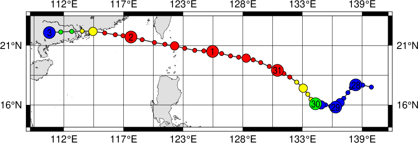
|
Year
|
Month
|
Day
|
Hour
|
Lat.
|
Long.
|
Wind (kt)
|
Gust (kt)
|
Direc. of Major Storm Axis
|
Radius of Major Storm Axis (nm)
|
Radius of Minor Storm Axis (nm)
|
Direc. of Major Gale Axis
|
Radius of Major Gale Axis (nm)
|
Radius of Minor Gale Axis (nm)
|
Image
|
| 2003 |
8 |
27 |
18 |
17.6 |
139.5 |
0 |
0 |
- |
- |
- |
- |
- |
- |
Image |
| 2003 |
8 |
28 |
00 |
17.8 |
138.1 |
0 |
0 |
- |
- |
- |
- |
- |
- |
Image |
| 2003 |
8 |
28 |
06 |
17.1 |
137.4 |
0 |
0 |
- |
- |
- |
- |
- |
- |
Image |
| 2003 |
8 |
28 |
12 |
16.2 |
136.7 |
0 |
0 |
- |
- |
- |
- |
- |
- |
Image |
| 2003 |
8 |
28 |
18 |
16.0 |
136.5 |
0 |
0 |
- |
- |
- |
- |
- |
- |
Image |
| 2003 |
8 |
29 |
00 |
15.8 |
136.3 |
0 |
0 |
- |
- |
- |
- |
- |
- |
Image |
| 2003 |
8 |
29 |
06 |
16.0 |
135.4 |
0 |
0 |
- |
- |
- |
- |
- |
- |
Image |
| 2003 |
8 |
29 |
12 |
16.0 |
135.0 |
0 |
0 |
- |
- |
- |
- |
- |
- |
Image |
| 2003 |
8 |
29 |
18 |
16.0 |
134.7 |
35 |
0 |
- |
- |
- |
SW |
120 |
90 |
Image |
| 2003 |
8 |
30 |
00 |
16.1 |
134.5 |
45 |
0 |
- |
- |
- |
SW |
260 |
210 |
Image |
| 2003 |
8 |
30 |
06 |
16.5 |
134.1 |
50 |
0 |
- |
- |
- |
SE |
260 |
200 |
Image |
| 2003 |
8 |
30 |
12 |
17.5 |
133.4 |
55 |
0 |
N |
40 |
30 |
N |
260 |
180 |
Image |
| 2003 |
8 |
30 |
18 |
18.5 |
132.2 |
65 |
0 |
N |
80 |
30 |
NW |
300 |
120 |
Image |
| 2003 |
8 |
31 |
00 |
19.1 |
131.1 |
65 |
0 |
N |
80 |
30 |
NW |
300 |
120 |
Image |
| 2003 |
8 |
31 |
06 |
19.8 |
129.6 |
70 |
0 |
E |
80 |
30 |
NW |
280 |
140 |
Image |
| 2003 |
8 |
31 |
12 |
20.2 |
128.3 |
70 |
0 |
E |
80 |
30 |
NW |
280 |
160 |
Image |
| 2003 |
8 |
31 |
18 |
20.4 |
126.9 |
70 |
0 |
NE |
80 |
30 |
NW |
300 |
200 |
Image |
| 2003 |
9 |
1 |
00 |
20.8 |
125.3 |
80 |
0 |
NE |
80 |
30 |
NW |
325 |
200 |
Image |
| 2003 |
9 |
1 |
06 |
20.9 |
123.7 |
80 |
0 |
NE |
110 |
30 |
NE |
325 |
200 |
Image |
| 2003 |
9 |
1 |
12 |
21.3 |
121.9 |
80 |
0 |
NE |
130 |
30 |
NE |
300 |
150 |
Image |
| 2003 |
9 |
1 |
18 |
21.6 |
120.1 |
80 |
0 |
E |
150 |
30 |
E |
325 |
100 |
Image |
| 2003 |
9 |
2 |
00 |
22.1 |
118.0 |
80 |
0 |
SE |
180 |
50 |
E |
350 |
100 |
Image |
| 2003 |
9 |
2 |
06 |
22.3 |
116.6 |
70 |
0 |
SE |
180 |
40 |
E |
325 |
100 |
Image |
| 2003 |
9 |
2 |
12 |
22.6 |
114.6 |
60 |
0 |
SW |
80 |
20 |
E |
250 |
100 |
Image |
| 2003 |
9 |
2 |
18 |
22.6 |
112.7 |
45 |
0 |
- |
- |
- |
E |
200 |
100 |
Image |
| 2003 |
9 |
3 |
00 |
22.5 |
110.7 |
0 |
0 |
- |
- |
- |
- |
- |
- |
Image |
|

