|
2005-07-19
Typhoon HAITANG spent a full day to move across Taiwan. Taiwan is a very steep island and its center is a row of mountains whose altitude are more than 4000 meters. It is a situation that obstacles of 4000 meters high lie in front of typhoons whose height is about 10,000 meters to 15,000 meters, so it is like humans go over obstacles of the height of hip, and it requires the waste of energy for crossing Taiwan. Typhoon HAITANG, which was very strong before making landfall, now weakened significantly, but evacuation measures are now in effect in China to prepare for disasters before the landfall of the typhoon.
2005-07-18
Typhoon HAITANG is affecting Sakishima for a long period of time with strong winds, and the maximum gust of 54.8m/s was recorded at Yonaguni Island. The typhoon then made landfall at Taiwan, and it is now weakening, but flash floods and landlides were already reported in Taiwan.
2005-07-17
Typhoon HAITANG has reached as strong as 915hPa in the evening of yesterday. During yesterday night, beautifully spiral cloud pattern and the crisp eye had been seen on satellite images, which indicated the peak of the typhoon. A catastrophic typhoon like this will maintain its power even after the peak in the weakening stage. The possibility of direct hit against Sakishima is getting lower, but the affect of strong winds and heavy rains may not be avoided. And it is concerned that the east coast of Taiwan will be directly striked by the typhoon.
Anyway, for the research of this typhoon in the future, it is highly regrettable that we cannot add the visible images into the database.
2005-07-16
Typhoon HAITANG is still growing larger and developing stronger, and with the clear eye and thick clouds around the center, it became the first serious typhoon in 2005 typhoon season. The typhoon is moving westward, but it also started to turn a little northward. It is still uncertain if it will move further north to draw near to Sakishima Islands, or move straight to hit Taiwan, but in any case those areas should be on alert.
2005-07-15
Typhoon HAITANG shows a cloud pattern being more balanced than yesterday, and the eye is getting more and more apparent in the center. For the past day, it looked as if it was preparing for further deepening, and it may restart intensification again for the next day.
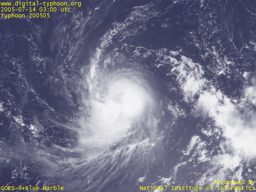
2005-07-14
Typhoon HAITANG is gradually increasing its size and keeps intensifying. It looks the structure of clouds at the center has not developed enough to form the eye, but the forecast says that it will develop into a fairly strong typhoon within a few days.
By the way, at twelve noon today (0300 UTC), the dissemination of GOES-9 satellite data was stopped. The image below is the wallpaper-sized magnified image of Typhoon HAITANG using the last image of GOES-9. The dissemination of visible images was also terminated, so the generation of wallpaper-sized images like this will not be available for the moment.
2005-07-13
Typhoon HAITANG's cloud system is getting developed, and although it is still small, it is showing the sign of deepening.
For your information, the system was in disorder yesterday just after the formation of the typhoon, but it has recovered to normal operation by this morning.
2005-07-12
Typhoon HAITANG was born in 0000 UTC of June 12, 2005, but the system shows the incorrect time of birth, three hours behind the correct time. The corection of this information will be deferred to the next year.
By the way, the system is still in trouble, and I am sorry for inconvenience. This system trouble is due to my lazyness toward testing the system after the switchover to Himawari-6 satellite. The system is recovering, but still it takes some time for complete recovery.
By the night of today, the system is close to normal operations, but it is still not perfect. By tomorrow it is expected to operate as specified.
Links
Related Typhoon Blog Entries
- Cyclone ZOE
- Typhoon 200704 (MAN-YI)
- Typhoon 200321 (LUPIT)
- Typhoon 200510 (SANVU)
- Typhoon 200504 (NESAT)
- Typhoon 200705 (USAGI)
- Typhoon 200908 (MORAKOT)
- Typhoon 200617 (RUMBIA)
- Typhoon 200401 (SUDAL)
- 2005 Cyclone INGRID
|