|
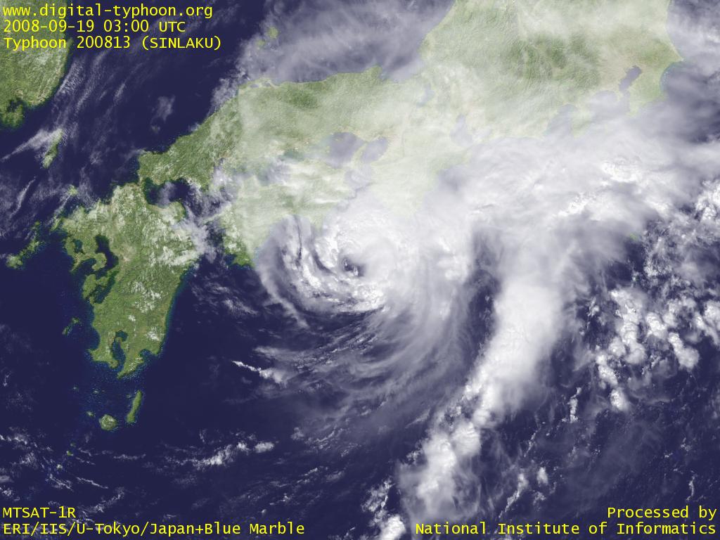
2008-09-19 18:00 JST
Typhoon SINLAKU passed near Tanegashima, and is moving in south of Kyushu, Shikoku, and Honshu. This typhoon gives larger impacts on rains rather than winds, and it still has very active clouds with slow speed, causing heavy rains in many places across Japan. Referring to AMeDAS Event Detection, especially heavy rainfall has been observed in Kagoshima, Miyazaki, and Mie prefecture, and the 24 hour rainfall of more than 700mm was observed at Owase. Active clouds of this typhoon are expected to move east toward Izu Islands and its neighborhood.
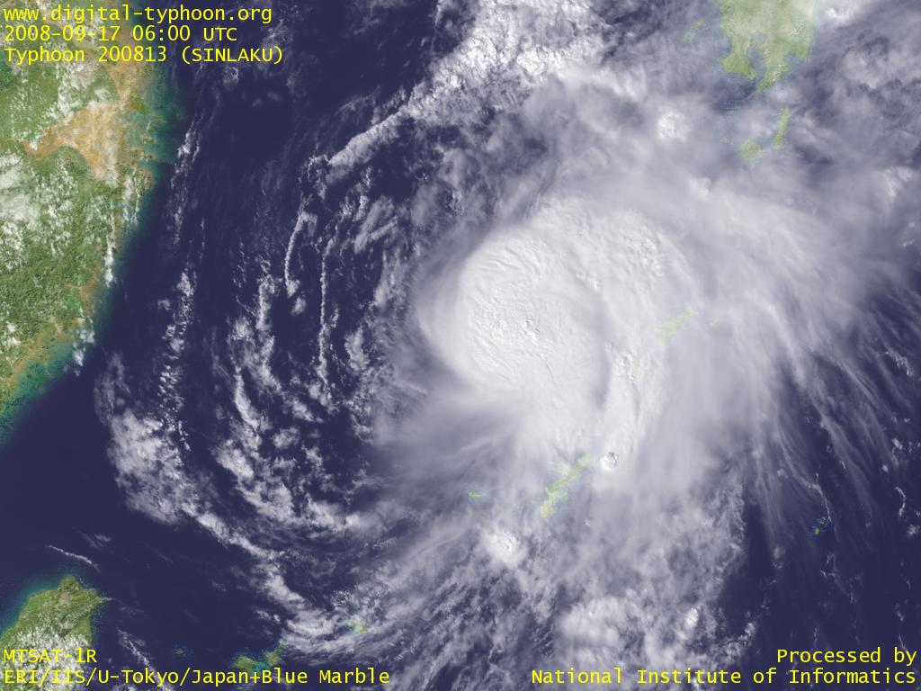
2008-09-18 00:00 JST
Typhoon SINLAKU could not re-intensify as initially forecast, maybe due to the lack of clouds in the west of the center, leading to unbalanced shape. It however is recovering gradually, and has the area of 50kt winds or more again. Active rainy clouds are extending to the south, causing heavy rains in Okinawa and Amami Islands, but this is more a blessed rain to solve the problem of water shortage.
2008-09-15 23:00 JST
Typhoon SINLAKU changed its track to eastward after leaving Taiwan, as if it is making a U-turn toward Japan. Okinawa and Kyushu will be affected by the typhoon in a few days.
At this moment the focus is on the degree of re-intensification of this typhoon. It was once strong at Sakishima Islands, but it is now weakened after making landfall in Taiwan. It seems, however, that satellite images indicate the gradual recovery of the typhoon. Clouds to the west of the center are weak after making landfall in Taiwan, but clouds to the east, which are originally very active, still remain, and there are other active clouds in the south. Now the effect of this typhoon depends on the degree of recovery.
A good example of typhoon recovery can be found in Typhoon 200318, which recorded an unprecedented track of a huge loop in the Pacific Ocean. The typhoon intensified in the beginning, but it weakened as it reached the area of bad conditions. Nevertheless, one week after, it came back to the place where it was strong before, and started re-intensification, and it recovered to a similar intensity in the end. We should pay attention to this typhoon if this is another example of recovering typhoons after weakening because of better conditions.
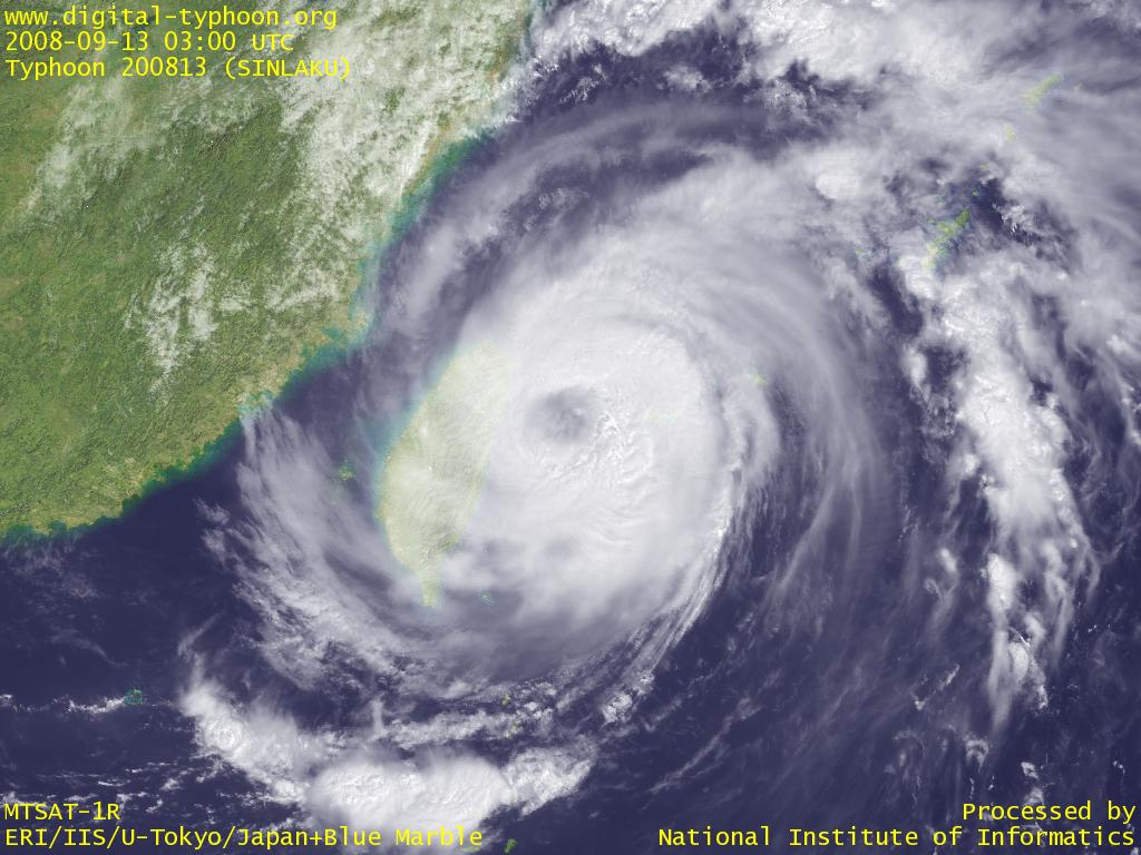
2008-09-14 22:00 JST
Typhoon SINLAKU made landfall in Taiwan, and passed across the north of Taiwan to reach Taiwan Strait. One person is reported to be killed, and the flood and heavy rains affected the society. The slow speed of the typhoon also affected Yonagunijima for almost two days with very strong winds, and the 24 hour precipitation of 769.5mm is 11th in the history of AMeDAS observations. The typhoon is forecast to change its direction from west to north and then east, but it seems that the turn of the movement is later than forecast before.
2008-09-13 21:15 JST
Typhoon SINLAKU caused record-breaking heavy rain at Yonagunijima today, September 13. As of 20 JST (11 UTC), in comparison to AMeDAS data since 1976 for Japan, 403mm of 6 hour precipitation is 11th on record, 614 mm of 12 hour precipitation is 6th on record, and 760mm of 24 hour precipitation is 12th on record. The severe weather is now stopped for a while, but it is also forecast to stay near the current location, so it may cause additional heavy rain until tomorrow morning. (AMeDAS data has not been updated since then due to the trouble of the data source).
2008-09-13 15:30 JST
Typhoon SINLAKU is still moving slowly around Yaeyema Islands. It keeps moving northwestward, so there is now possibility that it will not make landfall in Taiwan, and will pass near Taiwan to turn east in East China Sea. The cloud image below indicates that there are very active rainy clouds in the east of the center, and the radar and nowcast image shows that Yonagunijima is just under these active clouds, which brought very severe weather. AMeDAS data at Yonagunijima shows that the maximum wind of more than 30m/s has been observed since 20 JST of September 12, almost about one day ago.
2008-09-13 10:15 JST
Typhoon SINLAKU is stationary around Sakishima Islands, and now reached a point 50km from Yonagunijima after making a zigzag track moving west or northwest (see Google Earth Version). Severe weather is observed in Sakishima Islands; the maximum wind of 43m/s and the maximum gust of 62.8m/s was observed at Yonagunijima, and the 24 hour rainfall of more than 600mm was observed at Ishigakijima (Kabira) ( The largest on record). The east coast of Taiwan is already inside the area of 50kt winds or more, but it is still not clear whether the typhoon will make landfall in Taiwan, depending on the subtle change of the movement of the typhoon.
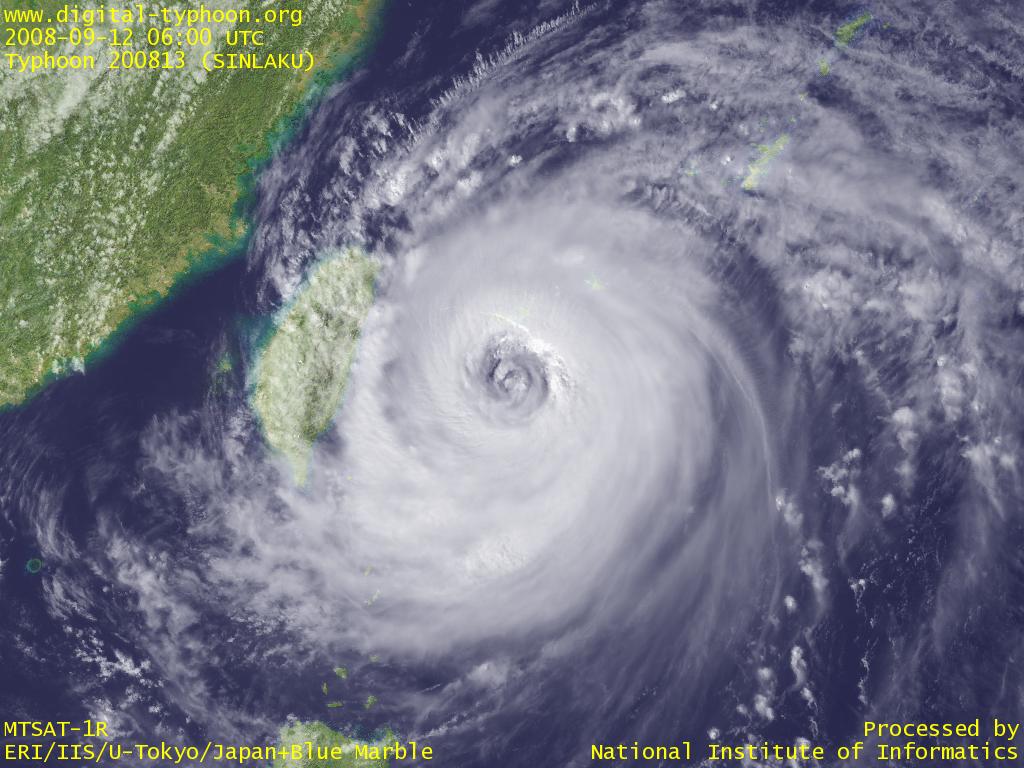
2008-09-12 21:00 JST
Typhoon SINLAKU turned westward in south of Sakishima Islands. Google Earth Version shows that, as of 18:00 JST (09:00 UTC), the center is located about 50km south of Hateruma Island, and Hateruma Island is now in the boundary between the eyewall clouds and the inside of the eye. On the other hand, Ishigakijima and Iriomotejima is covered by the core clouds of the typhoon and very severe rains and winds are being observed (refer to AMeRAS, AMeRAS Google Maps, and Event Detection). Yonagunijima, however, has a little more time before the typhoon passes the closest point.
In terms of the forecast of this typhoon, Japan Meteorological Agency hit the mark on the westward turn of the typhoon. It is too early to be relieved, because this typhoon is slow and difficult to forecast, so it is still not clear if this typhoon will make landfall in Taiwan after approaching near, and how it will move after that.
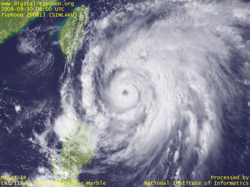
2008-09-10 21:30 JST
Typhoon SINLAKU keeps intensification in south of Sakishima Islands. The eye of the typhoon is getting more visible on the today's satellite image. The typhoon is forecast to keep moving northward with further intensification, and Sakishima Islands will soon be within the area of 30kt winds or more.
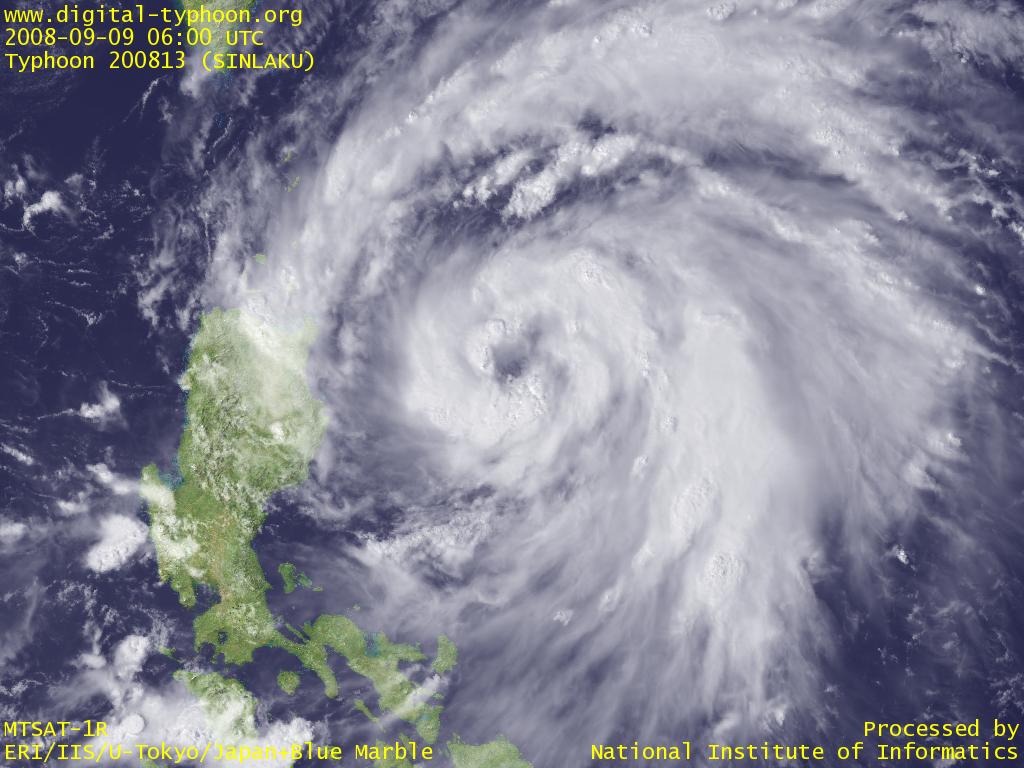
2008-09-09 19:00 JST
Typhoon SINLAKU is moving northward in east of Philippines, and the typhoon may keep intensification for the time being because the surrounding clouds around the center are well balanced, and the sea surface temperature in the neighborhood is high enough. There is a void space without clouds near the center, but it may be still premature to call it as an eye.
2008-09-09 09:00 JST
Typhoon SINLAKU was formed in east of Philippines. It is forecast to move northward for a while with steady intensification.
Related Typhoon Blog Entries
- Typhoon 200706 (PABUK)
- Typhoon 200908 (MORAKOT)
- Typhoon 200424 (NOCK-TEN)
- Typhoon 201317 (TORAJI)
- Typhoon 200715 (KROSA)
- Typhoon 201214 (TEMBIN)
- Typhoon 200916 (KETSANA)
- Typhoon 200427 (NANMADOL)
- Typhoon 200408 (TINGTING)
- Typhoon 200423 (TOKAGE)
|