1. Cyclone ZOE
2003-1-5
 It may not be a pleasant flight for people flying to Tikopia Island, a
small isolated island in the middle of the South Pacific Ocean, just
after the strike of the tropical cyclone Zoe, which was one of the
most powerful tropical cyclone ever recorded in that area.
Based on
meteorological satellite images, the local meteorological agency
estimated its intensity to be the strongest class with maximum wind
exceeding 80 meters per second. These figures remind us of the worst
case -- the island was totally demolished by devastating wind, and
washed away by a series of huge storm surges.
The press people, who were then flying to the island for studying the
extent of the disaster, were afraid that they would see a number of
casualties in the island. But, to their surprise, they discovered that
the islanders had no casualties because of the killer storm, thanks to
their appropriate decision making. That is, all the people in the
island decided to evacuate into a cave in the center of the island,
where they knew is the safest place in the island. This decision
making saved the lives of islanders.
Their decision making sounds even more miracle when we realize that
this tropical cyclone has shown a so-called "rapid deepening," the
unexpected intensification of the tropical cyclone in a short period
of time. Unexpectedly rapid intensification often leads to severe
disasters, because people are attacked by tropical cyclones before
their preparedness reaches the level of tropical cyclones after
intensification. Fortunatelly, the islanders could collect necessary
information and they also knew where they were safe.
It may not be a pleasant flight for people flying to Tikopia Island, a
small isolated island in the middle of the South Pacific Ocean, just
after the strike of the tropical cyclone Zoe, which was one of the
most powerful tropical cyclone ever recorded in that area.
Based on
meteorological satellite images, the local meteorological agency
estimated its intensity to be the strongest class with maximum wind
exceeding 80 meters per second. These figures remind us of the worst
case -- the island was totally demolished by devastating wind, and
washed away by a series of huge storm surges.
The press people, who were then flying to the island for studying the
extent of the disaster, were afraid that they would see a number of
casualties in the island. But, to their surprise, they discovered that
the islanders had no casualties because of the killer storm, thanks to
their appropriate decision making. That is, all the people in the
island decided to evacuate into a cave in the center of the island,
where they knew is the safest place in the island. This decision
making saved the lives of islanders.
Their decision making sounds even more miracle when we realize that
this tropical cyclone has shown a so-called "rapid deepening," the
unexpected intensification of the tropical cyclone in a short period
of time. Unexpectedly rapid intensification often leads to severe
disasters, because people are attacked by tropical cyclones before
their preparedness reaches the level of tropical cyclones after
intensification. Fortunatelly, the islanders could collect necessary
information and they also knew where they were safe.
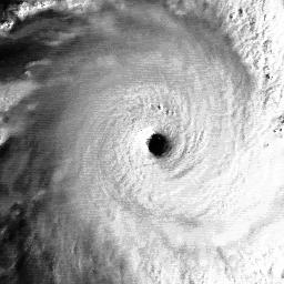
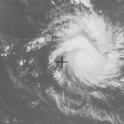
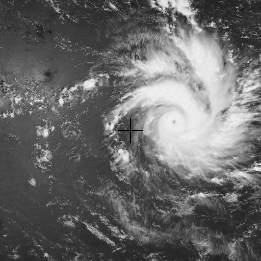
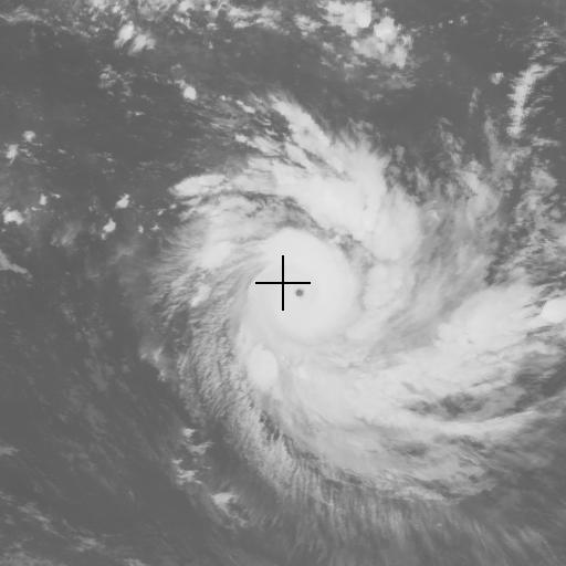
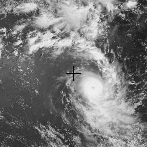
- A wallpaper-sized image of Cyclone ZOE at its peak intensity (December 27, 2002 1200UTC) -- 1024x768 (IR1) : 2800km in width and 2100km in height. It is estimated (JTWC) at the time of this picture that the maximum sustained wind was 155kt (80m/s), and the maximum gust even reached 190kt (100m/s).
- Animation of Cyclone ZOE
2. Related News
- The Australian: Islanders' miracle survival [ 04jan03 ]
- Cyclone Zoe report
- About Cyclone Zoe hits Solomon archipelago
- CNN.com - Cyclone wrecks Pacific islands
- EO Natural Hazards: Tropical Cyclone Zoe
- Reuters AlertNet - Cyclone Zoe, Solomon Islands
- Herald Sun: Cyclone Zoe builds strength
- Tropical Cyclones 2002-03: "ZOE"
- TRMM
- ソロモン諸島を襲った猛烈な台風
3. Image Collection
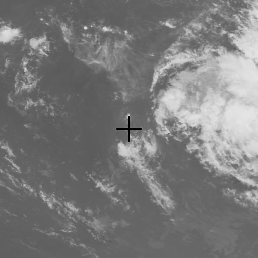
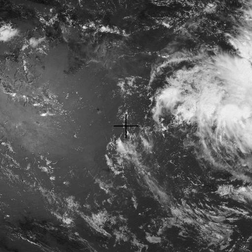
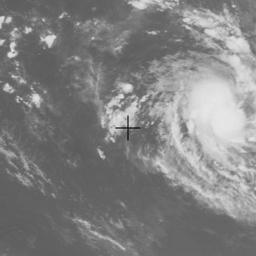
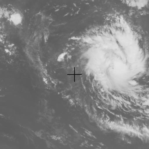
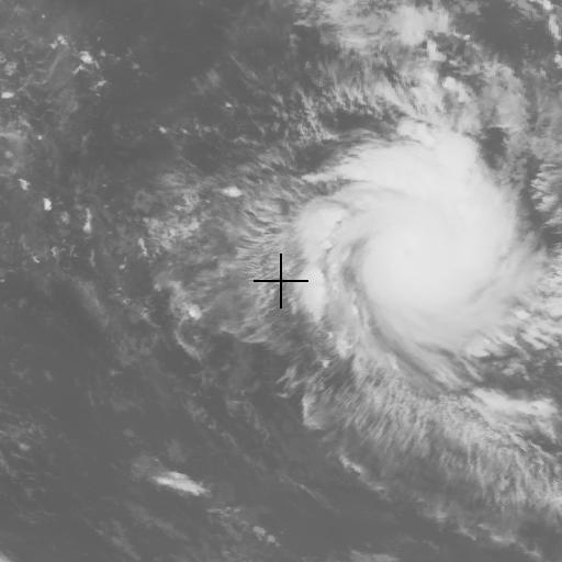
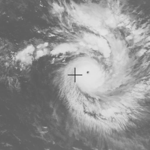
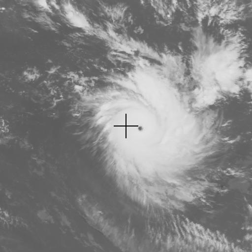
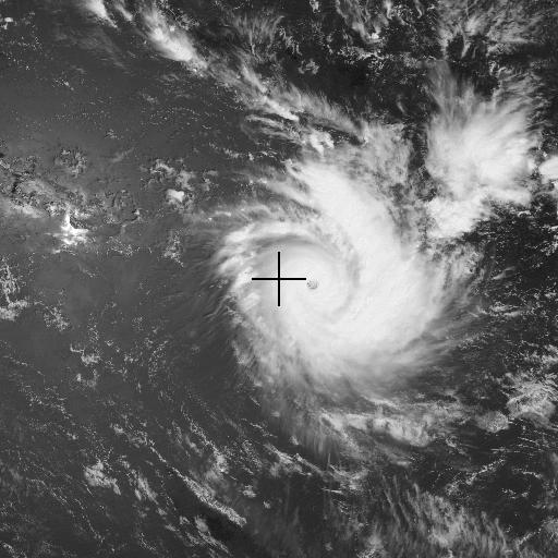
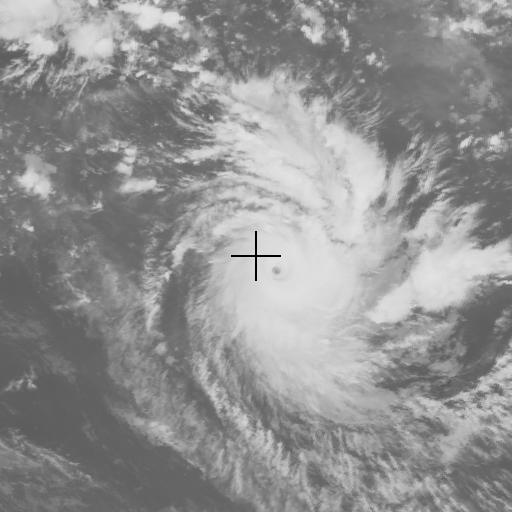
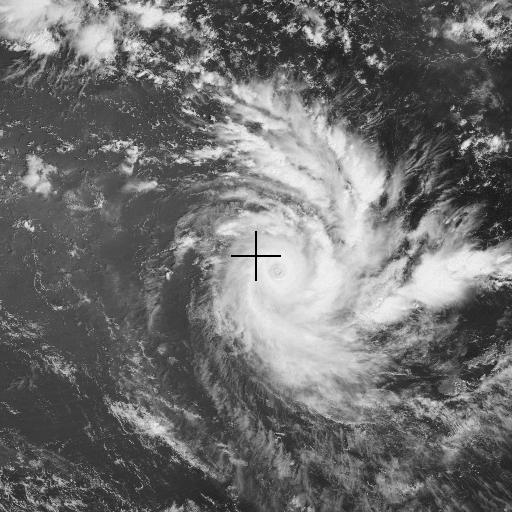
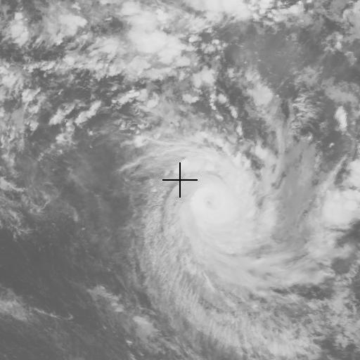
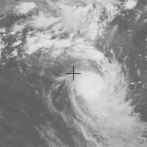
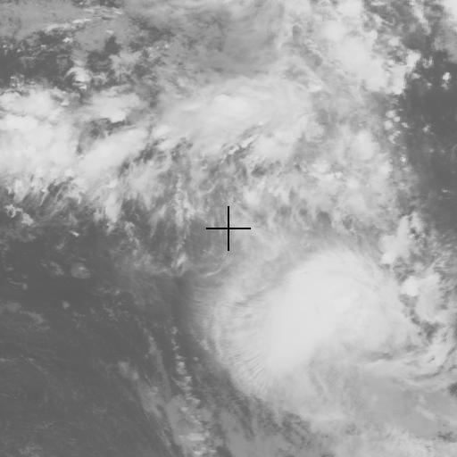
Images below are observed by the Japanese geostationary meteorological satellite GMS-5, its infrared sensor (IR1), and visible sensor (VIS). The center of the image is fixed to Tikopia Is. (S12.1, E168.5), Solomon Islands. The time zone is UTC. The maximum sustained wind (knots) in parentheses shows the analysis by Joint Typhoon Warning Center.
- MPEG movie (101 KBytes).
- Global image / Dec. 27, 2002, 1200 UTC / IR1: 2048x2048 (433 KBytes).
- Global image / Dec. 27, 2002, 0000 UTC / VIS: 2048x2048 (663 KBytes).
- Global image / Dec. 27, 2002, 0000 UTC / VIS: 4096x4096 (2.1 MBytes).
- Global image / Dec. 27, 2002, 0000 UTC / VIS: 8192x8192 (6.4 MBytes).
| IR1 | VIS |
|---|---|
 |
 |
| 2002 / 12 / 25 0000 UTC | |
 |
|
| 2002 / 12 / 25 1200 UTC (35 kt) | |
 |
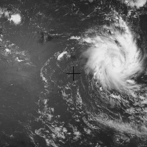 |
| 2002 / 12 / 26 0000 UTC (55 kt) | |
 |
|
| 2002 / 12 / 26 1200 UTC (75 kt) | |
 |
 |
| 2002 / 12 / 27 0000 UTC (95 kt) | |
 |
|
| 2002 / 12 / 27 1200 UTC (155 kt) | |
 |
 |
| 2002 / 12 / 28 0000 UTC (155 kt) | |
 |
|
| 2002 / 12 / 28 1200 UTC (145 kt) | |
 |
 |
| 2002 / 12 / 29 0000 UTC (120 kt) | |
 |
|
| 2002 / 12 / 29 1200 UTC (100 kt) | |
 |
 |
| 2002 / 12 / 30 0000 UTC (95 kt) | |
 |
|
| 2002 / 12 / 30 1200 UTC (75 kt) | |
Related Typhoon Blog Entries
2025
2024
- Summary of Typhoons in 2024
- Typhoon 202426 (PABUK)
- Typhoon 202425 (USAGI)
- Typhoon 202424 (MAN-YI)
- Typhoon 202423 (TORAJI)
- Typhoon 202422 (YINXING)
- Typhoon 202421 (KONG-REY)
- Typhoon 202420 (TRAMI)
- Typhoon 202419 (BARIJAT)
- Typhoon 202418 (KRATHON)
- Typhoon 202417 (JEBI)
- Typhoon 202416 (CIMARON)
- Typhoon 202415 (SOULIK)
- Typhoon 202414 (PULASAN)
- Typhoon 202413 (BEBINCA)
- Typhoon 202412 (LEEPI)
- Typhoon 202411 (YAGI)
- Typhoon 202410 (SHANSHAN)
- Typhoon 202409 (JONGDARI)
- Typhoon 202408 (WUKONG)
- Typhoon 202407 (AMPIL)
- Typhoon 202406 (SON-TINH)
- Typhoon 202405 (MARIA)
- Typhoon 202404 (PRAPIROON)
- Typhoon 202403 (GAEMI)
- Typhoon 202402 (MALIKSI)
- Typhoon 202401 (EWINIAR)
2023
- Summary of Typhoons in 2023
- Typhoon 202317 (JELAWAT)
- Typhoon 202316 (SANBA)
- Typhoon 202315 (BOLAVEN)
- Typhoon 202314 (KOINU)
- Typhoon 202313 (YUN-YEUNG)
- Typhoon 202312 (KIROGI)
- Typhoon 202311 (HAIKUI)
- Typhoon 202310 (DAMREY)
- Typhoon 202309 (SAOLA)
- Typhoon 202308 (DORA)
- Typhoon 202307 (LAN)
- Typhoon 202306 (KHANUN)
- Typhoon 202305 (DOKSURI)
- Typhoon 202304 (TALIM)
- Typhoon 202303 (GUCHOL)
- Typhoon 202302 (MAWAR)
- Typhoon 202301 (SANVU)
2022
- Summary of Typhoons in 2022
- Typhoon 202225 (PAKHAR)
- Typhoon 202224 (YAMANEKO)
- Typhoon 202223 (BANYAN)
- Typhoon 202222 (NALGAE)
- Typhoon 202221 (HAITANG)
- Typhoon 202220 (NESAT)
- Typhoon 202219 (SONCA)
- Typhoon 202218 (ROKE)
- Typhoon 202217 (KULAP)
- Typhoon 202216 (NORU)
- Typhoon 202215 (TALAS)
- Typhoon 202214 (NANMADOL)
- Typhoon 202213 (MERBOK)
- Typhoon 202212 (MUIFA)
- Typhoon 202211 (HINNAMNOR)
- Typhoon 202210 (TOKAGE)
- Typhoon 202209 (MA-ON)
- Typhoon 202208 (MEARI)
- Typhoon 202207 (MULAN)
- Typhoon 202206 (TRASES)
- Typhoon 202205 (SONGDA)
- Typhoon 202204 (AERE)
- Typhoon 202203 (CHABA)
- Typhoon 202202 (MEGI)
- Typhoon 202201 (MALAKAS)
2021
- Summary of Typhoons in 2021
- Typhoon 202122 (RAI)
- Typhoon 202121 (NYATOH)
- Typhoon 202120 (MALOU)
- Typhoon 202119 (NAMTHEUN)
- Typhoon 202118 (KOMPASU)
- Typhoon 202117 (LIONROCK)
- Typhoon 202116 (MINDULLE)
- Typhoon 202115 (DIANMU)
- Typhoon 202114 (CHANTHU)
- Typhoon 202113 (CONSON)
- Typhoon 202112 (OMAIS)
- Typhoon 202111 (NIDA)
- Typhoon 202110 (MIRINAE)
- Typhoon 202109 (LUPIT)
- Typhoon 202108 (NEPARTAK)
- Typhoon 202107 (CEMPAKA)
- Typhoon 202106 (IN-FA)
- Typhoon 202105 (CHAMPI)
- Typhoon 202104 (KOGUMA)
- Typhoon 202103 (CHOI-WAN)
- Typhoon 202102 (SURIGAE)
- Typhoon 202101 (DUJUAN)
2020
- Summary of Typhoons in 2020
- Typhoon 202023 (KROVANH)
- Typhoon 202022 (VAMCO)
- Typhoon 202021 (ETAU)
- Typhoon 202020 (ATSANI)
- Typhoon 202019 (GONI)
- Typhoon 202018 (MOLAVE)
- Typhoon 202017 (SAUDEL)
- Typhoon 202016 (NANGKA)
- Typhoon 202015 (LINFA)
- Typhoon 202014 (CHAN-HOM)
- Typhoon 202013 (KUJIRA)
- Typhoon 202012 (DOLPHIN)
- Typhoon 202011 (NOUL)
- Typhoon 202010 (HAISHEN)
- Typhoon 202009 (MAYSAK)
- Typhoon 202008 (BAVI)
- Typhoon 202007 (HIGOS)
- Typhoon 202006 (MEKKHALA)
- Typhoon 202005 (JANGMI)
- Typhoon 202004 (HAGUPIT)
- Typhoon 202003 (SINLAKU)
- Typhoon 202002 (NURI)
- Typhoon 202001 (VONGFONG)
2019
- Summary of Typhoons in 2019
- Typhoon 201929 (PHANFONE)
- Typhoon 201928 (KAMMURI)
- Typhoon 201927 (FUNG-WONG)
- Typhoon 201926 (KALMAEGI)
- Typhoon 201925 (FENGSHEN)
- Typhoon 201924 (NAKRI)
- Typhoon 201923 (HALONG)
- Typhoon 201922 (MATMO)
- Typhoon 201921 (BUALOI)
- Typhoon 201920 (NEOGURI)
- Typhoon 201919 (HAGIBIS)
- Typhoon 201918 (MITAG)
- Typhoon 201917 (TAPAH)
- Typhoon 201916 (PEIPAH)
- Typhoon 201915 (FAXAI)
- Typhoon 201914 (KAJIKI)
- Typhoon 201913 (LINGLING)
- Typhoon 201912 (PODUL)
- Typhoon 201911 (BAILU)
- Typhoon 201910 (KROSA)
- Typhoon 201909 (LEKIMA)
- Typhoon 201908 (FRANCISCO)
- Typhoon 201907 (WIPHA)
- Typhoon 201906 (NARI)
- Typhoon 201905 (DANAS)
- Typhoon 201904 (MUN)
- Typhoon 201903 (SEPAT)
- Typhoon 201902 (WUTIP)
- Typhoon 201901 (PABUK)
2018
- Summary of Typhoons in 2018
- Typhoon 201829 (USAGI)
- Typhoon 201828 (MAN-YI)
- Typhoon 201827 (TORAJI)
- Typhoon 201826 (YUTU)
- Typhoon 201825 (KONG-REY)
- Typhoon 201824 (TRAMI)
- Typhoon 201823 (BARIJAT)
- Typhoon 201822 (MANGKHUT)
- Typhoon 201821 (JEBI)
- Typhoon 201820 (CIMARON)
- Typhoon 201819 (SOULIK)
- Typhoon 201818 (RUMBIA)
- Typhoon 201817 (HECTOR)
- Typhoon 201816 (BEBINCA)
- Typhoon 201815 (LEEPI)
- Typhoon 201814 (YAGI)
- Typhoon 201813 (SHANSHAN)
- Typhoon 201812 (JONGDARI)
- Typhoon 201811 (WUKONG)
- Typhoon 201810 (AMPIL)
- Typhoon 201809 (SON-TINH)
- Typhoon 201808 (MARIA)
- Typhoon 201807 (PRAPIROON)
- Typhoon 201806 (GAEMI)
- Typhoon 201805 (MALIKSI)
- Typhoon 201804 (EWINIAR)
- Typhoon 201803 (JELAWAT)
- Typhoon 201802 (SANBA)
- Typhoon 201801 (BOLAVEN)
2017
- Summary of Typhoons in 2017
- Typhoon 201727 (TEMBIN)
- Typhoon 201726 (KAI-TAK)
- Typhoon 201725 (KIROGI)
- Typhoon 201724 (HAIKUI)
- Typhoon 201723 (DAMREY)
- Typhoon 201722 (SAOLA)
- Typhoon 201721 (LAN)
- Typhoon 201720 (KHANUN)
- Typhoon 201719 (DOKSURI)
- Typhoon 201718 (TALIM)
- Typhoon 201717 (GUCHOL)
- Typhoon 201716 (MAWAR)
- Typhoon 201715 (SANVU)
- Typhoon 201714 (PAKHAR)
- Typhoon 201713 (HATO)
- Typhoon 201712 (BANYAN)
- Typhoon 201711 (NALGAE)
- Typhoon 201710 (HAITANG)
- Typhoon 201709 (NESAT)
- Typhoon 201708 (SONCA)
- Typhoon 201707 (ROKE)
- Typhoon 201706 (KULAP)
- Typhoon 201705 (NORU)
- Typhoon 201704 (TALAS)
- Typhoon 201703 (NANMADOL)
- Typhoon 201702 (MERBOK)
- Typhoon 201701 (MUIFA)
2016
- Summary of Typhoons in 2016
- Typhoon 201626 (NOCK-TEN)
- Typhoon 201625 (TOKAGE)
- Typhoon 201624 (MA-ON)
- Typhoon 201623 (MEARI)
- Typhoon 201622 (HAIMA)
- Typhoon 201621 (SARIKA)
- Typhoon 201620 (SONGDA)
- Typhoon 201619 (AERE)
- Typhoon 201618 (CHABA)
- Typhoon 201617 (MEGI)
- Typhoon 201616 (MALAKAS)
- Typhoon 201615 (RAI)
- Typhoon 201614 (MERANTI)
- Typhoon 201613 (MALOU)
- Typhoon 201612 (NAMTHEUN)
- Typhoon 201611 (KOMPASU)
- Typhoon 201610 (LIONROCK)
- Typhoon 201609 (MINDULLE)
- Typhoon 201608 (DIANMU)
- Typhoon 201607 (CHANTHU)
- Typhoon 201606 (CONSON)
- Typhoon 201605 (OMAIS)
- Typhoon 201604 (NIDA)
- Typhoon 201603 (MIRINAE)
- Typhoon 201602 (LUPIT)
- Typhoon 201601 (NEPARTAK)
2015
- Summary of Typhoons in 2015
- Typhoon 201527 (MELOR)
- Typhoon 201526 (IN-FA)
- Typhoon 201525 (CHAMPI)
- Typhoon 201524 (KOPPU)
- Typhoon 201523 (CHOI-WAN)
- Typhoon 201522 (MUJIGAE)
- Typhoon 201521 (DUJUAN)
- Typhoon 201520 (KROVANH)
- Typhoon 201519 (VAMCO)
- Typhoon 201518 (ETAU)
- Typhoon 201517 (KILO)
- Typhoon 201516 (ATSANI)
- Typhoon 201515 (GONI)
- Typhoon 201514 (MOLAVE)
- Typhoon 201513 (SOUDELOR)
- Typhoon 201512 (HALOLA)
- Typhoon 201511 (NANGKA)
- Typhoon 201510 (LINFA)
- Typhoon 201509 (CHAN-HOM)
- Typhoon 201508 (KUJIRA)
- Typhoon 201507 (DOLPHIN)
- Typhoon 201506 (NOUL)
- Typhoon 201505 (HAISHEN)
- Typhoon 201504 (MAYSAK)
- Typhoon 201503 (BAVI)
- Typhoon 201502 (HIGOS)
- Typhoon 201501 (MEKKHALA)
2014
- Summary of Typhoons in 2014
- Typhoon 201423 (JANGMI)
- Typhoon 201422 (HAGUPIT)
- Typhoon 201421 (SINLAKU)
- Typhoon 201420 (NURI)
- Typhoon 201419 (VONGFONG)
- Typhoon 201418 (PHANFONE)
- Typhoon 201417 (KAMMURI)
- Typhoon 201416 (FUNG-WONG)
- Typhoon 201415 (KALMAEGI)
- Typhoon 201414 (FENGSHEN)
- Typhoon 201413 (GENEVIEVE)
- Typhoon 201412 (NAKRI)
- Typhoon 201411 (HALONG)
- Typhoon 201410 (MATMO)
- Typhoon 201409 (RAMMASUN)
- Typhoon 201408 (NEOGURI)
- Typhoon 201407 (HAGIBIS)
- Typhoon 201406 (MITAG)
- Typhoon 201405 (TAPAH)
- Typhoon 201404 (PEIPAH)
- Typhoon 201403 (FAXAI)
- Typhoon 201402 (KAJIKI)
- Typhoon 201401 (LINGLING)
2013
- Summary of Typhoons in 2013
- Typhoon 201331 (PODUL)
- Typhoon 201330 (HAIYAN)
- Typhoon 201329 (KROSA)
- Typhoon 201328 (LEKIMA)
- Typhoon 201327 (FRANCISCO)
- Typhoon 201326 (WIPHA)
- Typhoon 201325 (NARI)
- Typhoon 201324 (DANAS)
- Typhoon 201323 (FITOW)
- Typhoon 201322 (SEPAT)
- Typhoon 201321 (WUTIP)
- Typhoon 201320 (PABUK)
- Typhoon 201319 (USAGI)
- Typhoon 201318 (MAN-YI)
- Typhoon 201317 (TORAJI)
- Typhoon 201316 (YUTU)
- Typhoon 201315 (KONG-REY)
- Typhoon 201314 (UNALA)
- Typhoon 201313 (PEWA)
- Typhoon 201312 (TRAMI)
- Typhoon 201311 (UTOR)
- Typhoon 201310 (MANGKHUT)
- Typhoon 201309 (JEBI)
- Typhoon 201308 (CIMARON)
- Typhoon 201307 (SOULIK)
- Typhoon 201306 (RUMBIA)
- Typhoon 201305 (BEBINCA)
- Typhoon 201304 (LEEPI)
- Typhoon 201303 (YAGI)
- Typhoon 201302 (SHANSHAN)
- Typhoon 201301 (SONAMU)
2012
- Summary of Typhoons in 2012
- Typhoon 201225 (WUKONG)
- Typhoon 201224 (BOPHA)
- Typhoon 201223 (SON-TINH)
- Typhoon 201222 (MARIA)
- Typhoon 201221 (PRAPIROON)
- Typhoon 201220 (GAEMI)
- Typhoon 201219 (MALIKSI)
- Typhoon 201218 (EWINIAR)
- Typhoon 201217 (JELAWAT)
- Typhoon 201216 (SANBA)
- Typhoon 201215 (BOLAVEN)
- Typhoon 201214 (TEMBIN)
- Typhoon 201213 (KAI-TAK)
- Typhoon 201212 (KIROGI)
- Typhoon 201211 (HAIKUI)
- Typhoon 201210 (DAMREY)
- Typhoon 201209 (SAOLA)
- Typhoon 201208 (VICENTE)
- Typhoon 201207 (KHANUN)
- Typhoon 201206 (DOKSURI)
- Typhoon 201205 (TALIM)
- Typhoon 201204 (GUCHOL)
- Typhoon 201203 (MAWAR)
- Typhoon 201202 (SANVU)
- Typhoon 201201 (PAKHAR)
2011
- Summary of Typhoons in 2011
- Typhoon 201121 (WASHI)
- Typhoon 201120 (BANYAN)
- Typhoon 201119 (NALGAE)
- Typhoon 201118 (HAITANG)
- Typhoon 201117 (NESAT)
- Typhoon 201116 (SONCA)
- Typhoon 201115 (ROKE)
- Typhoon 201114 (KULAP)
- Typhoon 201113 (NORU)
- Typhoon 201112 (TALAS)
- Typhoon 201111 (NANMADOL)
- Typhoon 201110 (MERBOK)
- Typhoon 201109 (MUIFA)
- Typhoon 201108 (NOCK-TEN)
- Typhoon 201107 (TOKAGE)
- Typhoon 201106 (MA-ON)
- Typhoon 201105 (MEARI)
- Typhoon 201104 (HAIMA)
- Typhoon 201103 (SARIKA)
- Typhoon 201102 (SONGDA)
- Typhoon 201101 (AERE)
2010
- Summary of Typhoons in 2010
- Typhoon 201014 (CHABA)
- Typhoon 201013 (MEGI)
- Typhoon 201012 (MALAKAS)
- Typhoon 201011 (FANAPI)
- Typhoon 201010 (MERANTI)
- Typhoon 201009 (MALOU)
- Typhoon 201008 (NAMTHEUN)
- Typhoon 201007 (KOMPASU)
- Typhoon 201006 (LIONROCK)
- Typhoon 201005 (MINDULLE)
- Typhoon 201004 (DIANMU)
- Typhoon 201003 (CHANTHU)
- Typhoon 201002 (CONSON)
- Typhoon 201001 (OMAIS)
2009
- Summary of Typhoons in 2009
- Typhoon 200922 (NIDA)
- Typhoon 200921 (MIRINAE)
- Typhoon 200920 (LUPIT)
- Typhoon 200919 (NEPARTAK)
- Typhoon 200918 (MELOR)
- Typhoon 200917 (PARMA)
- Typhoon 200916 (KETSANA)
- Typhoon 200915 (KOPPU)
- Typhoon 200914 (CHOI-WAN)
- Typhoon 200913 (MUJIGAE)
- Typhoon 200912 (DUJUAN)
- Typhoon 200911 (KROVANH)
- Typhoon 200910 (VAMCO)
- Typhoon 200909 (ETAU)
- Typhoon 200908 (MORAKOT)
- Typhoon 200907 (GONI)
- Typhoon 200906 (MOLAVE)
- Typhoon 200905 (SOUDELOR)
- Typhoon 200904 (NANGKA)
- Typhoon 200903 (LINFA)
- Typhoon 200902 (CHAN-HOM)
- Typhoon 200901 (KUJIRA)
2008
- Summary of Typhoons in 2008
- Typhoon 200822 (DOLPHIN)
- Typhoon 200821 (NOUL)
- Typhoon 200820 (HAISHEN)
- Typhoon 200819 (MAYSAK)
- Typhoon 200818 (BAVI)
- Typhoon 200817 (HIGOS)
- Typhoon 200816 (MEKKHALA)
- Typhoon 200815 (JANGMI)
- Typhoon 200814 (HAGUPIT)
- Typhoon 200813 (SINLAKU)
- Typhoon 200812 (NURI)
- Typhoon 200811 (VONGFONG)
- Typhoon 200810 (PHANFONE)
- Typhoon 200809 (KAMMURI)
- Typhoon 200808 (FUNG-WONG)
- Typhoon 200807 (KALMAEGI)
- Typhoon 200806 (FENGSHEN)
- Typhoon 200805 (NAKRI)
- Typhoon 200804 (HALONG)
- Typhoon 200803 (MATMO)
- Typhoon 200802 (RAMMASUN)
- Typhoon 200801 (NEOGURI)
2007
- Summary of Typhoons in 2007
- Typhoon 200724 (HAGIBIS)
- Typhoon 200723 (MITAG)
- Typhoon 200722 (TAPAH)
- Typhoon 200721 (PEIPAH)
- Typhoon 200720 (FAXAI)
- Typhoon 200719 (KAJIKI)
- Typhoon 200718 (LINGLING)
- Typhoon 200717 (PODUL)
- Typhoon 200716 (HAIYAN)
- Typhoon 200715 (KROSA)
- Typhoon 200714 (LEKIMA)
- Typhoon 200713 (FRANCISCO)
- Typhoon 200712 (WIPHA)
- Typhoon 200711 (NARI)
- Typhoon 200710 (DANAS)
- Typhoon 200709 (FITOW)
- Typhoon 200708 (SEPAT)
- Typhoon 200707 (WUTIP)
- Typhoon 200706 (PABUK)
- Typhoon 200705 (USAGI)
- Typhoon 200704 (MAN-YI)
- Typhoon 200703 (TORAJI)
- Typhoon 200702 (YUTU)
- Typhoon 200701 (KONG-REY)
2006
- Summary of Typhoons in 2006
- Typhoon 200623 (TRAMI)
- Typhoon 200622 (UTOR)
- Typhoon 200621 (DURIAN)
- Typhoon 200620 (CHEBI)
- Typhoon 200619 (CIMARON)
- Typhoon 200618 (SOULIK)
- Typhoon 200617 (RUMBIA)
- Typhoon 200616 (BEBINCA)
- Typhoon 200615 (XANGSANE)
- Typhoon 200614 (YAGI)
- Typhoon 200613 (SHANSHAN)
- Typhoon 200612 (IOKE)
- Typhoon 200611 (SONAMU)
- Typhoon 200610 (WUKONG)
- Typhoon 200609 (BOPHA)
- Typhoon 200608 (SAOMAI)
- Typhoon 200607 (MARIA)
- Typhoon 200606 (PRAPIROON)
- Typhoon 200605 (KAEMI)
- Typhoon 200604 (BILIS)
- Typhoon 200603 (EWINIAR)
- Typhoon 200602 (JELAWAT)
- Typhoon 200601 (CHANCHU)
2005
- Summary of Typhoons in 2005
- Typhoon 200523 (BOLAVEN)
- Typhoon 200522 (TEMBIN)
- Typhoon 200521 (KAI-TAK)
- Typhoon 200520 (KIROGI)
- Typhoon 200519 (LONGWANG)
- Typhoon 200518 (DAMREY)
- Typhoon 200517 (SAOLA)
- Typhoon 200516 (VICENTE)
- Typhoon 200515 (KHANUN)
- Typhoon 200514 (NABI)
- Typhoon 200513 (TALIM)
- Typhoon 200512 (GUCHOL)
- Typhoon 200511 (MAWAR)
- Typhoon 200510 (SANVU)
- Typhoon 200509 (MATSA)
- Typhoon 200508 (WASHI)
- Typhoon 200507 (BANYAN)
- Typhoon 200506 (NALGAE)
- Typhoon 200505 (HAITANG)
- Typhoon 200504 (NESAT)
- Typhoon 200503 (SONCA)
- Typhoon 200502 (ROKE)
- 2005 Cyclone INGRID
- 2005 Cyclone MEENA
- Typhoon 200501 (KULAP)
2004
- Summary of Typhoons in 2004
- Typhoon 200429 (NORU)
- Typhoon 200428 (TALAS)
- Typhoon 200427 (NANMADOL)
- Typhoon 200426 (MERBOK)
- Typhoon 200425 (MUIFA)
- Typhoon 200424 (NOCK-TEN)
- Typhoon 200423 (TOKAGE)
- Typhoon 200422 (MA-ON)
- Typhoon 200421 (MEARI)
- Typhoon 200420 (HAIMA)
- Typhoon 200419 (SARIKA)
- Typhoon 200418 (SONGDA)
- Typhoon 200417 (AERE)
- Typhoon 200416 (CHABA)
- Typhoon 200415 (MEGI)
- Typhoon 200414 (MALAKAS)
- Typhoon 200413 (RANANIM)
- Typhoon 200412 (MERANTI)
- Typhoon 200411 (MALOU)
- Typhoon 200410 (NAMTHEUN)
- Typhoon 200409 (KOMPASU)
- Typhoon 200408 (TINGTING)
- Typhoon 200407 (MINDULLE)
- Typhoon 200406 (DIANMU)
- Typhoon 200405 (CHANTHU)
- Typhoon 200404 (CONSON)
- Typhoon 200403 (OMAIS)
- Typhoon 200402 (NIDA)
- Typhoon 200401 (SUDAL)
- 2004 Cyclone IVY
- 2004 Cyclone HETA
2003
- Summary of Typhoons in 2003
- 2003 Cyclone JANA
- Typhoon 200321 (LUPIT)
- Typhoon 200320 (NEPARTAK)
- Typhoon 200319 (MELOR)
- Typhoon 200318 (PARMA)
- Typhoon 200317 (KETSANA)
- Typhoon 200316 (KOPPU)
- Typhoon 200315 (CHOI-WAN)
- Typhoon 200314 (MAEMI)
- Typhoon 200313 (DUJUAN)
- Typhoon 200312 (KROVANH)
- Typhoon 200311 (VAMCO)
- Typhoon 200310 (ETAU)
- Typhoon 200309 (MORAKOT)
- Typhoon 200308 (KONI)
- Typhoon 200307 (IMBUDO)
- Typhoon 200306 (SOUDELOR)
- Typhoon 200305 (NANGKA)
- Typhoon 200304 (LINFA)
- Typhoon 200303 (CHAN-HOM)
- Typhoon 200302 (KUJIRA)
- Typhoon 200301 (YANYAN)
- Cyclone ZOE
2002