1. 2005 Cyclone INGRID
2005-3-16
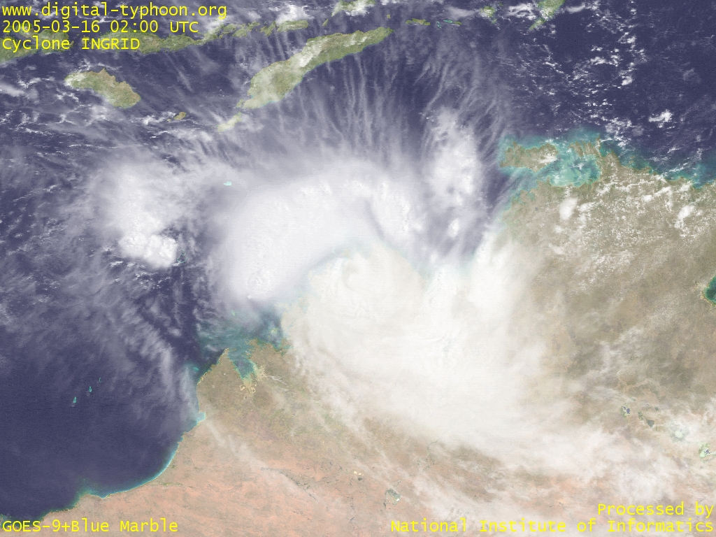
Cyclone INGRID survives to the last moment. It has weakened to the central pressure of 968hPa (Category 3), but its cloud system is still well organized. The track so far has been relatively close to the coast, so if it turns a little north and reaches open water, it has good momentum to revive itself again.
Cyclone INGRID is now moving on Western Australia, and it is reported that the remote resort of Kimberley, hit directly by the cyclone, had severe structural damage.
- Cyclone INGRID's amazing survival (March 16, 2005, 0200 UTC) -- 1024x768 (VIS) [EW 2000km x NS 1500km]
2005-3-15
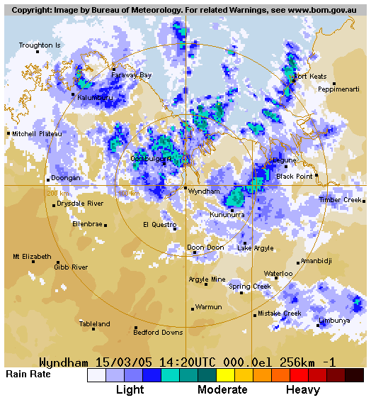
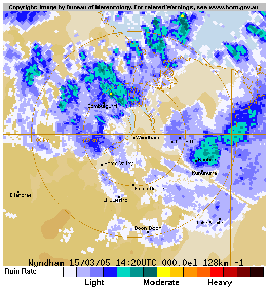
Cyclone INGRID has once again recovered its strength and intensified with the central pressure of 945hPa (Category 4). Its track, however, is getting more southward, so it will make landfall on the mainland in a short time, terminating its life of ups and downs.
In the evening the cyclone has once again reached the maximum intensity of 935hPa (Category 5). This cyclone really has a charmed life. Radar images above show the cyclone which seems to be just after making landfall, observed the radar at Wyndham.
|
|
- Cyclone INGRID extremely intensified again just before making landfall (March 15, 2005, 0600 UTC) -- 1024x768 (VIS) [EW 2000km x NS 1500km]
2005-3-14
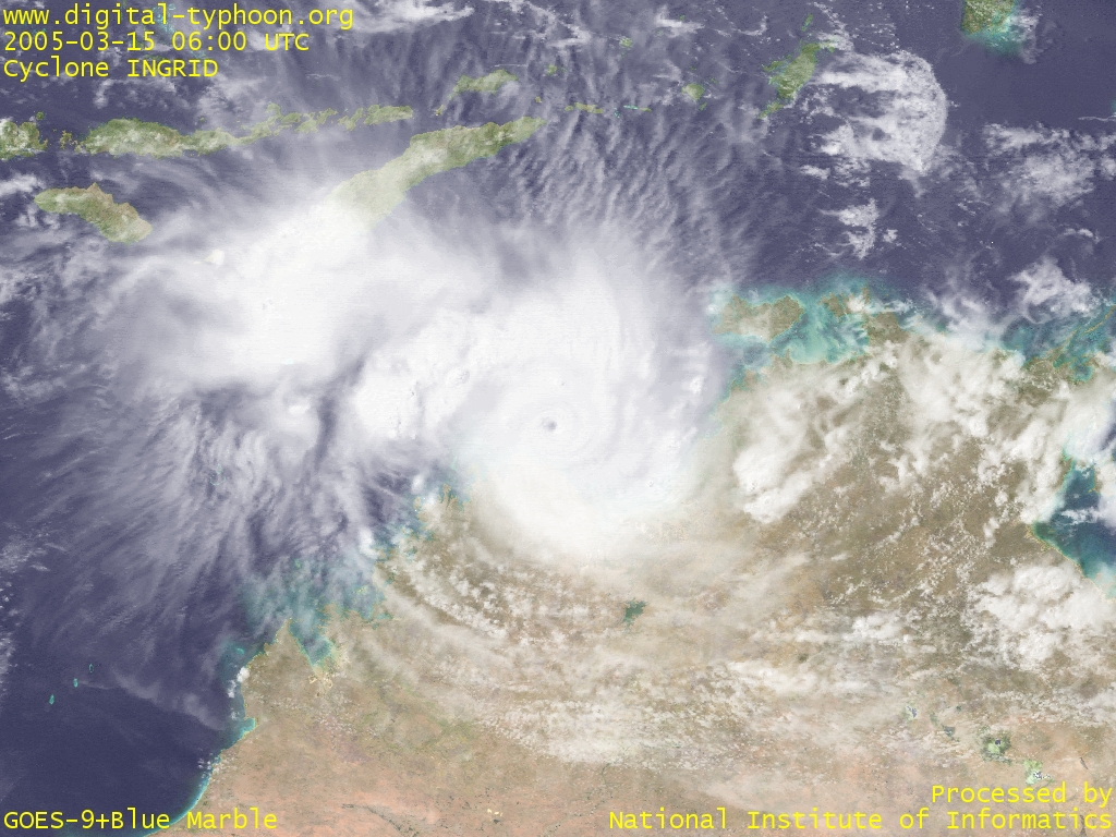
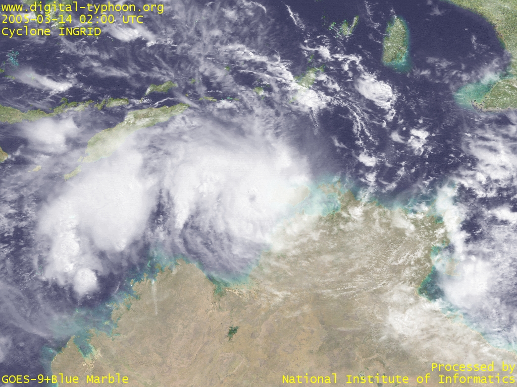
Cyclone INGRID has weakened into Category 3, but now it maintains its strength without signs of rapid weakening, partially because the cyclone is now moving over open water, the Timor Sea. The meteorological satellite image today still shows the presence of the eye. As the cyclone passed, severe structural damage has been reported from remote islands in north of Darwin, but what people in the mainland Australia really feel seems to be that they wished to have more rain from the cyclone.
- Cyclone INGRID reaching the Timor Sea with its eye still being visible (March 14, 2005, 0200 UTC) -- 1024x768 (VIS) [EW 2000km x NS 1500km]
2005-3-13
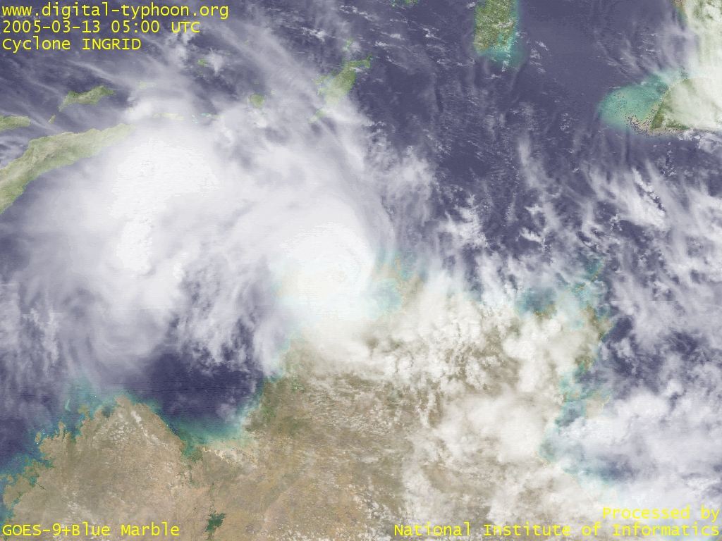
Cyclone INGRID has intensified to the central pressure of 925hPa (Category 5) with the maximum wind gusts of 320km/h, and reached its peak maturity during its lifetime. It is lucky that the very destructive core of the cyclone is moving over the sea, and it seems no major damage has been reported. But the capital of the Northern Territory, Darwin, is now on the highest cyclone warning alert and prepares for the cyclone.
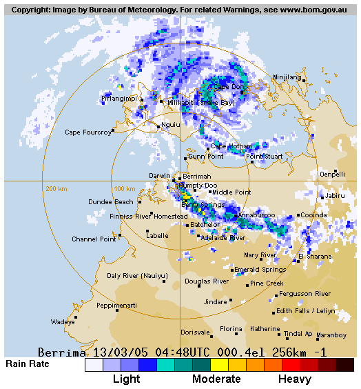
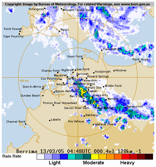
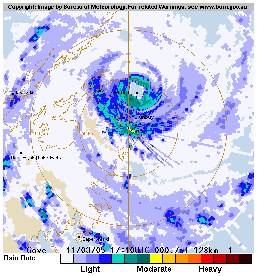
Afterwards, Cyclone INGRID reached the area of Cobourg Peninsula, and has weakened into Category 4. The cyclone's expected track passes near Melville island, and it is likely that the cyclone will weaken due to its movement over the land.
According to radar images provided from Bureau of Meteorology, the cyclone has weakened compared to the peak intensity yesterday, and although the eye is still present, the overall structure of clouds is getting smaller. The cyclone is located a little far from the capital, Darwin, but a band of clouds extending from the cyclone is bringing heavy rainfall on the mainland.
|
|
- Cyclone INGRID gradually weakening (March 13, 2005, 0500 UTC) -- 1024x768 (VIS) [EW 1600km x NS 1200km]
2005-3-12

|
|
- Cyclone INGRID moving along the coast of Top End (March 12, 2005, 0100 UTC) -- 1024x768 (VIS) [EW 1600km x NS 1200km]
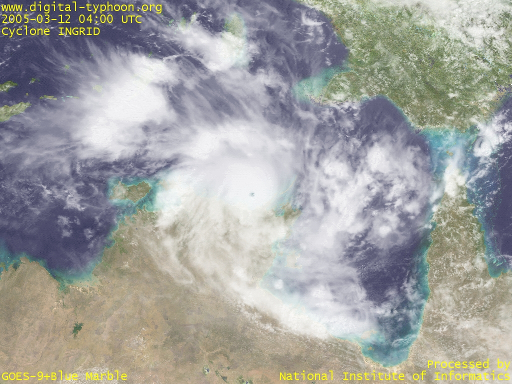
- Cyclone INGRID with the clear edge of the eye (March 12, 2005, 0400 UTC) -- 1024x768 (VIS) [EW 2000km x NS 1500km]
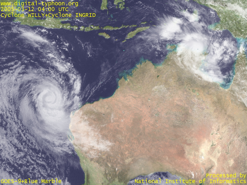
- Cyclone WILLY in west of Australia (left) and Cyclone INGRID in north of Australia (right) (March 12, 2005, 0400 UTC) -- 1024x768 (VIS) [EW 4400km x NS 3300km]
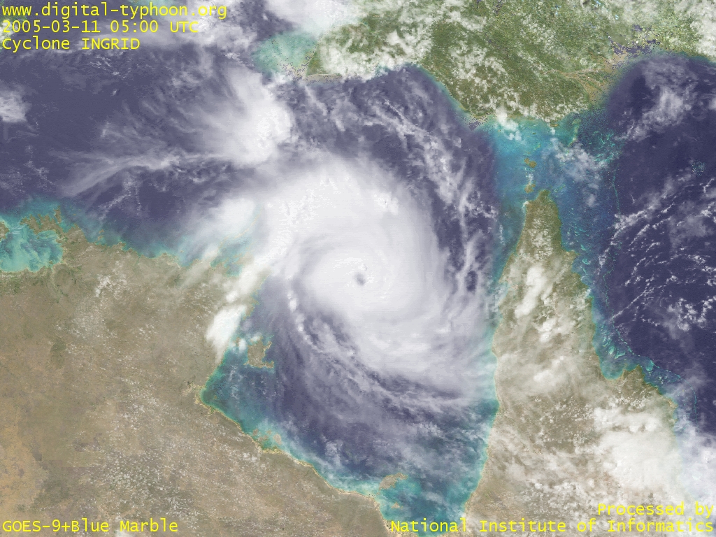
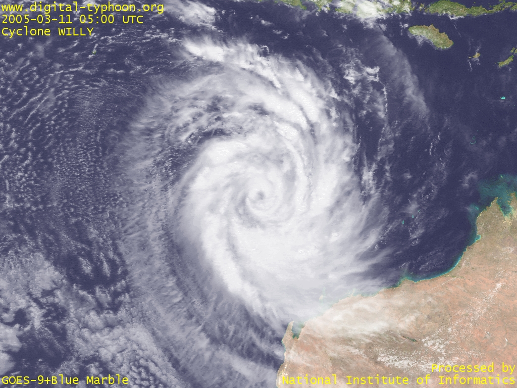
2005-3-11
Cyclone INGRID weakened after it traversed Cape York Peninsula, but it re-intensified after it moves over the warm Gulf of Carpentaria. On the other hand, Cyclone WILLY keeps intensification into a large cyclone.
The name WILLY is reminiscent of a well-known story that "a tropical cyclone is called Willy-Willy in Australia." The real Willy-Willy looks like this, however, and it is described as follows:
The term "willy willy" has been used for tornadoes and even tropical cyclones but its main use is for dust devils.The name Willy-Willy, moreover, does not appear in What is a hurricane, typhoon, or tropical cyclone. Hence we can say that the meaning of this term is NOT the cyclone as one name of tropical cyclones. The reason of this misunderstanding seems to be originated in a report made by European people who visited Australia and understood an Australian Aboriginal word with incorrect meanings (no citation at present). In fact, this is quite a typical misconception that tropical cyclones, tornadoes, and dust devils are all vortices, and hence all are "similar" phenomena. The charming sound (?) of "Willy-Willy" may further helped its diffusion over the world. Even Encyclopedia Britannica describes this word as
in western Australia, any large, travelling tropical cyclone.So this misunderstanding seems to linger for a while in spite of the fact that Willy-Willy is actually not being used in Australia to refer to tropical cyclones. Detailed discussion.
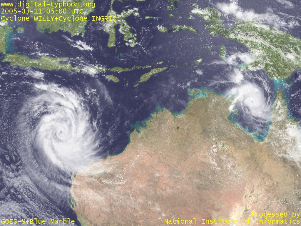
- Cyclone WILLY in its intensification (left) and Cyclone INGRID in its re-intensification (March 11, 2005, 0500 UTC) -- 1024x768 (VIS) [EW 4400km x NS 3300km]
- Cyclone INGRID magnified (March 11, 2005, 0500 UTC) -- 1024x768 (VIS) [EW 1600km x NS 1200km]
- Cyclone WILLY magnified (March 11, 2005, 0500 UTC) -- 1024x768 (VIS) [EW 2400km x NS 1800km]
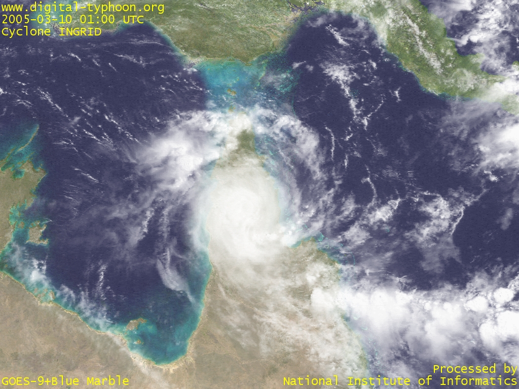
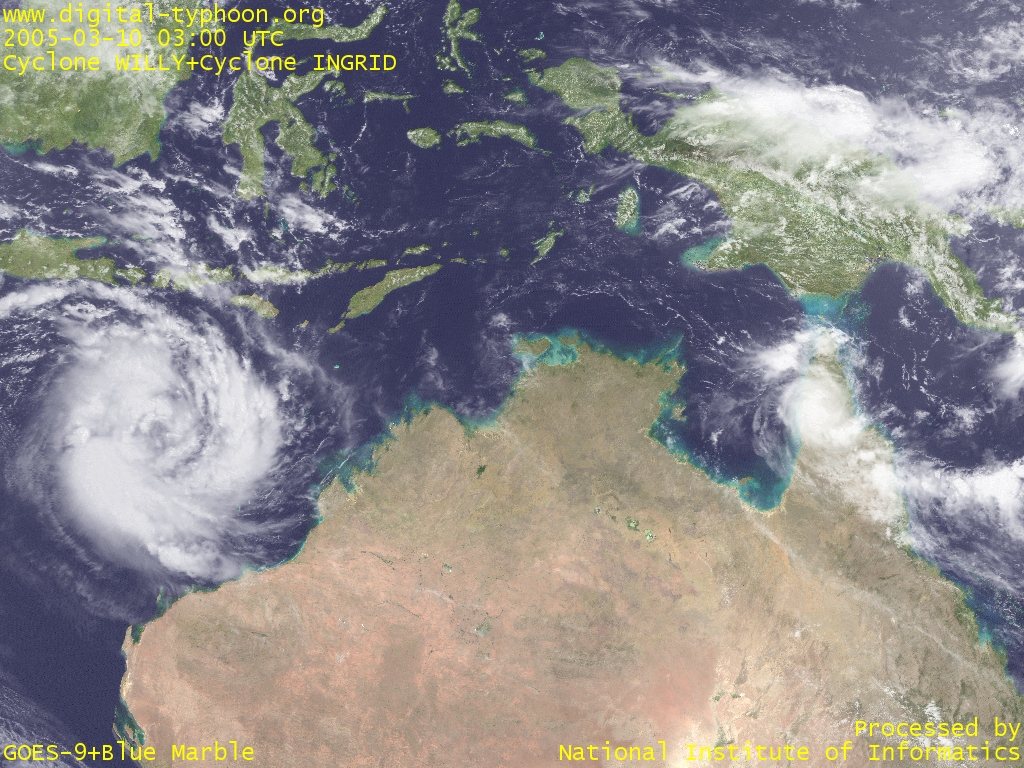
2005-3-10
Cyclone INGRID is just moving across Cape York Peninsula. It has weakened significantly from its peak maturity, but it still keeps its well-rounded shape, and it may indicate re-intensification after it reaches the Gulf of Carpentaria.
Another cyclone, Cyclone Willy, was generated in the Timor Sea in north-west of Australia. According to JTWC, it is forecast to move westward to the Indian Ocean, so it is likely to give little impact on the mainland Australia.
- Cyclone INGRID just crossing Cape York Peninsula (March 10, 2005, 0100 UTC) -- 1024x768 (VIS) [EW 1600km x NS 1200km]
- A large vortex of Cyclone WILLY (left) and a mini vortex of Cyclone INGRID (March 10, 2005, 0300 UTC) -- 1024x768 (VIS) [EW 4400km x NS 3300km]
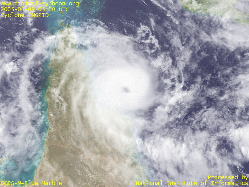
2005-3-9
Cyclone INGRID has weakened a little, and downgraded into Category 4, but it still keeps a strong intensity that has rarely be seen in Coral Sea. According to The Bureau of Meteorology, Australia, the central pressure is 935hPa and the maximum wind gusts are 280km/h (0700 EST). It seems that the cyclone is moving a little northward, so the effect of the cyclone may be smaller than expected around Cairns.
Among tropical cyclones that made landfall on the mainland Australia, this cyclone may become the strongest cyclone since Cyclone TRACY that hit Darwin in 1974. Related information : Cyclone Tracy.
- Cyclone INGRID weakening with its eye getting unclear (March 9, 2005, 0500 UTC) -- 1024x768 (VIS) [EW 1200km x NS 900km]
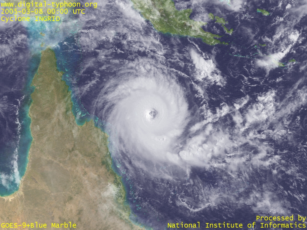
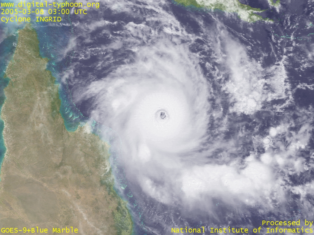
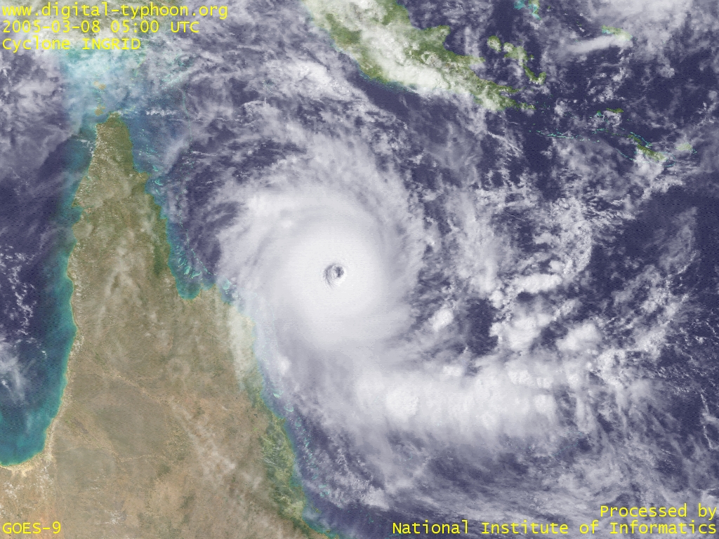
2005-3-8
Cyclone INGRID is approaching to the north Queensland coast, Australia. The forecast of maximum wind is 135kt, according to the forecast of JTWC, and it will draw near to north of Cairns. The Bureau of Meteorology, Australia says the central pressure is 930 hPa (Category 5), and the maximum wind gusts are 290 km/h (1000 EST). The mainland of Australia recorded only two category-5 cyclones in over 100 years, which fact indicates that this cyclone is a devastating cyclone at present.
The cyclone number by JTWC is 22P, and the satellite image below reminds me of the typhoon of the identical number, Typhoon 200422, which was also a small-sized but well-developed typhoon. The tropical cyclone of this type has very strong winds near the center.
- Cyclone INGRID approaching to the northern part of Australia (March 8, 2005, 0000 UTC) -- 1024x768 (VIS) [EW 1600km x NS 1200km]
- The core of Cyclone INGRID (March 8, 2005, 0300 UTC) -- 1024x768 (VIS) [EW 1200km x NS 900km]
- Cyclone INGRID with its clearly visible eye (March 8, 2005, 0500 UTC) -- 1024x768 (VIS) [EW 1600km x NS 1200km]
2005-3-8
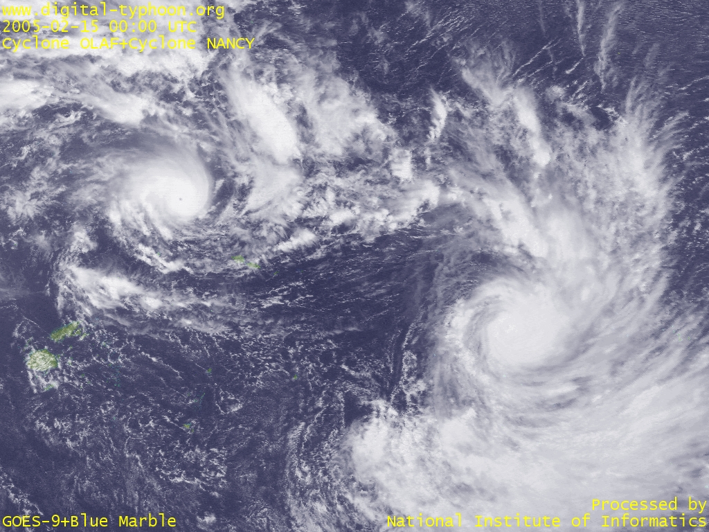
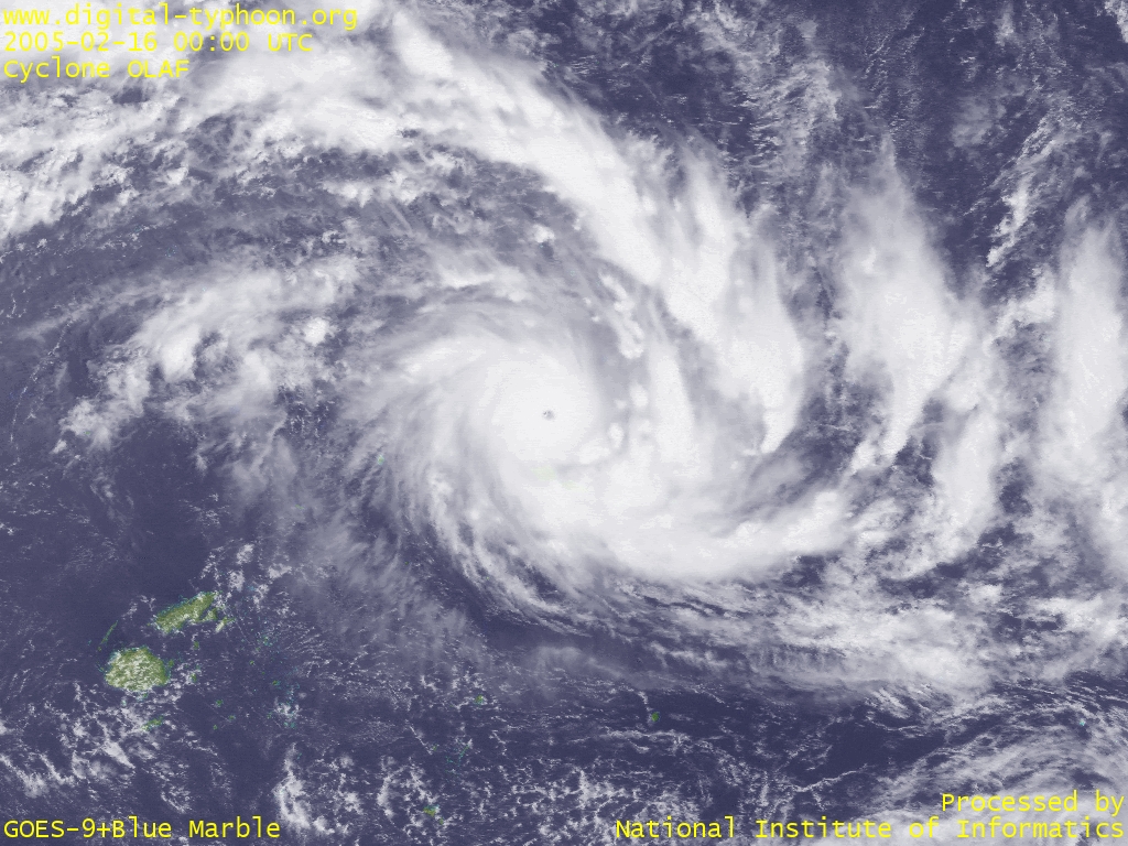
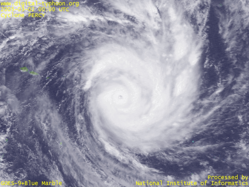
This cyclone season in the southern Pacific basin has seen intense cyclones in a row. After Cyclone MEENA (Max. Wind 125kt), strong cyclones such as Cyclone OLAF (Max. Wind 145kt), Cyclone NANCY (Max. Wind 125kt), and Cyclone PERCY (Max. Wind 140kt) have been generated one after another. In particular, Cook Islands suffered from the four successive strikes of cyclones, by which some islands and atolls within the area were severly damaged.
And as the image below shows, two cyclones, Cyclone OLAF and Cyclone NANCY, were generated within a very short distance, and it is said that two cyclones of so small distance is a rare event in this area of southern Pacific. Definitive opinions cannot be expressed due to the lack of good databases, but this and other facts may be an indication that the cyclone activity of this year is more intense than average. The succesive intensification of tropical cyclones is reminiscent of Typhoons in 2004 within North Western Pacific.
- Two Cyclones in the South Pacific: Cyclone OLAF (top left) and Cyclone NANCY (bottom right) (February 15, 2005, 0000 UTC) -- 1024x768 (VIS) [EW 3600km x NS 2700km]
- Cyclone OLAF at its peak of maturity near Samoa (February 16, 2005, 0000 UTC) -- 1024x768 (VIS) [EW 2800km x NS 2100km]
- Cyclone PERCY at its peak of maturity in north of Cook Island (March 2, 2005, 0000 UTC) -- 1024x768 (VIS) [EW 2000km x NS 1500km]
Links
-
EO Natural Hazards: Cyclone Ingrid
Satellite images of Cyclone INGRID by NASA.
http://earthobservatory.nasa.gov/NaturalHazards/natural_hazards_v2.php3?img_id=12776
-
EO Natural Hazards: Tropical Cyclone Percy
Satellite images of Tropical Cyclone PERCY by NASA.
http://earthobservatory.nasa.gov/NaturalHazards/natural_hazards_v2.php3?img_id=12750
-
EO Natural Hazards: Cyclones in the Pacific
Satellite images of Tropical Cyclone OLAF and Tropical Cyclone NANCY by NASA.
http://earthobservatory.nasa.gov/NaturalHazards/natural_hazards_v2.php3?img_id=12726
Related Typhoon Blog Entries
2024
2023
- Summary of Typhoons in 2023
- Typhoon 202317 (JELAWAT)
- Typhoon 202316 (SANBA)
- Typhoon 202315 (BOLAVEN)
- Typhoon 202314 (KOINU)
- Typhoon 202313 (YUN-YEUNG)
- Typhoon 202312 (KIROGI)
- Typhoon 202311 (HAIKUI)
- Typhoon 202310 (DAMREY)
- Typhoon 202309 (SAOLA)
- Typhoon 202308 (DORA)
- Typhoon 202307 (LAN)
- Typhoon 202306 (KHANUN)
- Typhoon 202305 (DOKSURI)
- Typhoon 202304 (TALIM)
- Typhoon 202303 (GUCHOL)
- Typhoon 202302 (MAWAR)
- Typhoon 202301 (SANVU)
2022
- Summary of Typhoons in 2022
- Typhoon 202225 (PAKHAR)
- Typhoon 202224 (YAMANEKO)
- Typhoon 202223 (BANYAN)
- Typhoon 202222 (NALGAE)
- Typhoon 202221 (HAITANG)
- Typhoon 202220 (NESAT)
- Typhoon 202219 (SONCA)
- Typhoon 202218 (ROKE)
- Typhoon 202217 (KULAP)
- Typhoon 202216 (NORU)
- Typhoon 202215 (TALAS)
- Typhoon 202214 (NANMADOL)
- Typhoon 202213 (MERBOK)
- Typhoon 202212 (MUIFA)
- Typhoon 202211 (HINNAMNOR)
- Typhoon 202210 (TOKAGE)
- Typhoon 202209 (MA-ON)
- Typhoon 202208 (MEARI)
- Typhoon 202207 (MULAN)
- Typhoon 202206 (TRASES)
- Typhoon 202205 (SONGDA)
- Typhoon 202204 (AERE)
- Typhoon 202203 (CHABA)
- Typhoon 202202 (MEGI)
- Typhoon 202201 (MALAKAS)
2021
- Summary of Typhoons in 2021
- Typhoon 202122 (RAI)
- Typhoon 202121 (NYATOH)
- Typhoon 202120 (MALOU)
- Typhoon 202119 (NAMTHEUN)
- Typhoon 202118 (KOMPASU)
- Typhoon 202117 (LIONROCK)
- Typhoon 202116 (MINDULLE)
- Typhoon 202115 (DIANMU)
- Typhoon 202114 (CHANTHU)
- Typhoon 202113 (CONSON)
- Typhoon 202112 (OMAIS)
- Typhoon 202111 (NIDA)
- Typhoon 202110 (MIRINAE)
- Typhoon 202109 (LUPIT)
- Typhoon 202108 (NEPARTAK)
- Typhoon 202107 (CEMPAKA)
- Typhoon 202106 (IN-FA)
- Typhoon 202105 (CHAMPI)
- Typhoon 202104 (KOGUMA)
- Typhoon 202103 (CHOI-WAN)
- Typhoon 202102 (SURIGAE)
- Typhoon 202101 (DUJUAN)
2020
- Summary of Typhoons in 2020
- Typhoon 202023 (KROVANH)
- Typhoon 202022 (VAMCO)
- Typhoon 202021 (ETAU)
- Typhoon 202020 (ATSANI)
- Typhoon 202019 (GONI)
- Typhoon 202018 (MOLAVE)
- Typhoon 202017 (SAUDEL)
- Typhoon 202016 (NANGKA)
- Typhoon 202015 (LINFA)
- Typhoon 202014 (CHAN-HOM)
- Typhoon 202013 (KUJIRA)
- Typhoon 202012 (DOLPHIN)
- Typhoon 202011 (NOUL)
- Typhoon 202010 (HAISHEN)
- Typhoon 202009 (MAYSAK)
- Typhoon 202008 (BAVI)
- Typhoon 202007 (HIGOS)
- Typhoon 202006 (MEKKHALA)
- Typhoon 202005 (JANGMI)
- Typhoon 202004 (HAGUPIT)
- Typhoon 202003 (SINLAKU)
- Typhoon 202002 (NURI)
- Typhoon 202001 (VONGFONG)
2019
- Summary of Typhoons in 2019
- Typhoon 201929 (PHANFONE)
- Typhoon 201928 (KAMMURI)
- Typhoon 201927 (FUNG-WONG)
- Typhoon 201926 (KALMAEGI)
- Typhoon 201925 (FENGSHEN)
- Typhoon 201924 (NAKRI)
- Typhoon 201923 (HALONG)
- Typhoon 201922 (MATMO)
- Typhoon 201921 (BUALOI)
- Typhoon 201920 (NEOGURI)
- Typhoon 201919 (HAGIBIS)
- Typhoon 201918 (MITAG)
- Typhoon 201917 (TAPAH)
- Typhoon 201916 (PEIPAH)
- Typhoon 201915 (FAXAI)
- Typhoon 201914 (KAJIKI)
- Typhoon 201913 (LINGLING)
- Typhoon 201912 (PODUL)
- Typhoon 201911 (BAILU)
- Typhoon 201910 (KROSA)
- Typhoon 201909 (LEKIMA)
- Typhoon 201908 (FRANCISCO)
- Typhoon 201907 (WIPHA)
- Typhoon 201906 (NARI)
- Typhoon 201905 (DANAS)
- Typhoon 201904 (MUN)
- Typhoon 201903 (SEPAT)
- Typhoon 201902 (WUTIP)
- Typhoon 201901 (PABUK)
2018
- Summary of Typhoons in 2018
- Typhoon 201829 (USAGI)
- Typhoon 201828 (MAN-YI)
- Typhoon 201827 (TORAJI)
- Typhoon 201826 (YUTU)
- Typhoon 201825 (KONG-REY)
- Typhoon 201824 (TRAMI)
- Typhoon 201823 (BARIJAT)
- Typhoon 201822 (MANGKHUT)
- Typhoon 201821 (JEBI)
- Typhoon 201820 (CIMARON)
- Typhoon 201819 (SOULIK)
- Typhoon 201818 (RUMBIA)
- Typhoon 201817 (HECTOR)
- Typhoon 201816 (BEBINCA)
- Typhoon 201815 (LEEPI)
- Typhoon 201814 (YAGI)
- Typhoon 201813 (SHANSHAN)
- Typhoon 201812 (JONGDARI)
- Typhoon 201811 (WUKONG)
- Typhoon 201810 (AMPIL)
- Typhoon 201809 (SON-TINH)
- Typhoon 201808 (MARIA)
- Typhoon 201807 (PRAPIROON)
- Typhoon 201806 (GAEMI)
- Typhoon 201805 (MALIKSI)
- Typhoon 201804 (EWINIAR)
- Typhoon 201803 (JELAWAT)
- Typhoon 201802 (SANBA)
- Typhoon 201801 (BOLAVEN)
2017
- Summary of Typhoons in 2017
- Typhoon 201727 (TEMBIN)
- Typhoon 201726 (KAI-TAK)
- Typhoon 201725 (KIROGI)
- Typhoon 201724 (HAIKUI)
- Typhoon 201723 (DAMREY)
- Typhoon 201722 (SAOLA)
- Typhoon 201721 (LAN)
- Typhoon 201720 (KHANUN)
- Typhoon 201719 (DOKSURI)
- Typhoon 201718 (TALIM)
- Typhoon 201717 (GUCHOL)
- Typhoon 201716 (MAWAR)
- Typhoon 201715 (SANVU)
- Typhoon 201714 (PAKHAR)
- Typhoon 201713 (HATO)
- Typhoon 201712 (BANYAN)
- Typhoon 201711 (NALGAE)
- Typhoon 201710 (HAITANG)
- Typhoon 201709 (NESAT)
- Typhoon 201708 (SONCA)
- Typhoon 201707 (ROKE)
- Typhoon 201706 (KULAP)
- Typhoon 201705 (NORU)
- Typhoon 201704 (TALAS)
- Typhoon 201703 (NANMADOL)
- Typhoon 201702 (MERBOK)
- Typhoon 201701 (MUIFA)
2016
- Summary of Typhoons in 2016
- Typhoon 201626 (NOCK-TEN)
- Typhoon 201625 (TOKAGE)
- Typhoon 201624 (MA-ON)
- Typhoon 201623 (MEARI)
- Typhoon 201622 (HAIMA)
- Typhoon 201621 (SARIKA)
- Typhoon 201620 (SONGDA)
- Typhoon 201619 (AERE)
- Typhoon 201618 (CHABA)
- Typhoon 201617 (MEGI)
- Typhoon 201616 (MALAKAS)
- Typhoon 201615 (RAI)
- Typhoon 201614 (MERANTI)
- Typhoon 201613 (MALOU)
- Typhoon 201612 (NAMTHEUN)
- Typhoon 201611 (KOMPASU)
- Typhoon 201610 (LIONROCK)
- Typhoon 201609 (MINDULLE)
- Typhoon 201608 (DIANMU)
- Typhoon 201607 (CHANTHU)
- Typhoon 201606 (CONSON)
- Typhoon 201605 (OMAIS)
- Typhoon 201604 (NIDA)
- Typhoon 201603 (MIRINAE)
- Typhoon 201602 (LUPIT)
- Typhoon 201601 (NEPARTAK)
2015
- Summary of Typhoons in 2015
- Typhoon 201527 (MELOR)
- Typhoon 201526 (IN-FA)
- Typhoon 201525 (CHAMPI)
- Typhoon 201524 (KOPPU)
- Typhoon 201523 (CHOI-WAN)
- Typhoon 201522 (MUJIGAE)
- Typhoon 201521 (DUJUAN)
- Typhoon 201520 (KROVANH)
- Typhoon 201519 (VAMCO)
- Typhoon 201518 (ETAU)
- Typhoon 201517 (KILO)
- Typhoon 201516 (ATSANI)
- Typhoon 201515 (GONI)
- Typhoon 201514 (MOLAVE)
- Typhoon 201513 (SOUDELOR)
- Typhoon 201512 (HALOLA)
- Typhoon 201511 (NANGKA)
- Typhoon 201510 (LINFA)
- Typhoon 201509 (CHAN-HOM)
- Typhoon 201508 (KUJIRA)
- Typhoon 201507 (DOLPHIN)
- Typhoon 201506 (NOUL)
- Typhoon 201505 (HAISHEN)
- Typhoon 201504 (MAYSAK)
- Typhoon 201503 (BAVI)
- Typhoon 201502 (HIGOS)
- Typhoon 201501 (MEKKHALA)
2014
- Summary of Typhoons in 2014
- Typhoon 201423 (JANGMI)
- Typhoon 201422 (HAGUPIT)
- Typhoon 201421 (SINLAKU)
- Typhoon 201420 (NURI)
- Typhoon 201419 (VONGFONG)
- Typhoon 201418 (PHANFONE)
- Typhoon 201417 (KAMMURI)
- Typhoon 201416 (FUNG-WONG)
- Typhoon 201415 (KALMAEGI)
- Typhoon 201414 (FENGSHEN)
- Typhoon 201413 (GENEVIEVE)
- Typhoon 201412 (NAKRI)
- Typhoon 201411 (HALONG)
- Typhoon 201410 (MATMO)
- Typhoon 201409 (RAMMASUN)
- Typhoon 201408 (NEOGURI)
- Typhoon 201407 (HAGIBIS)
- Typhoon 201406 (MITAG)
- Typhoon 201405 (TAPAH)
- Typhoon 201404 (PEIPAH)
- Typhoon 201403 (FAXAI)
- Typhoon 201402 (KAJIKI)
- Typhoon 201401 (LINGLING)
2013
- Summary of Typhoons in 2013
- Typhoon 201331 (PODUL)
- Typhoon 201330 (HAIYAN)
- Typhoon 201329 (KROSA)
- Typhoon 201328 (LEKIMA)
- Typhoon 201327 (FRANCISCO)
- Typhoon 201326 (WIPHA)
- Typhoon 201325 (NARI)
- Typhoon 201324 (DANAS)
- Typhoon 201323 (FITOW)
- Typhoon 201322 (SEPAT)
- Typhoon 201321 (WUTIP)
- Typhoon 201320 (PABUK)
- Typhoon 201319 (USAGI)
- Typhoon 201318 (MAN-YI)
- Typhoon 201317 (TORAJI)
- Typhoon 201316 (YUTU)
- Typhoon 201315 (KONG-REY)
- Typhoon 201314 (UNALA)
- Typhoon 201313 (PEWA)
- Typhoon 201312 (TRAMI)
- Typhoon 201311 (UTOR)
- Typhoon 201310 (MANGKHUT)
- Typhoon 201309 (JEBI)
- Typhoon 201308 (CIMARON)
- Typhoon 201307 (SOULIK)
- Typhoon 201306 (RUMBIA)
- Typhoon 201305 (BEBINCA)
- Typhoon 201304 (LEEPI)
- Typhoon 201303 (YAGI)
- Typhoon 201302 (SHANSHAN)
- Typhoon 201301 (SONAMU)
2012
- Summary of Typhoons in 2012
- Typhoon 201225 (WUKONG)
- Typhoon 201224 (BOPHA)
- Typhoon 201223 (SON-TINH)
- Typhoon 201222 (MARIA)
- Typhoon 201221 (PRAPIROON)
- Typhoon 201220 (GAEMI)
- Typhoon 201219 (MALIKSI)
- Typhoon 201218 (EWINIAR)
- Typhoon 201217 (JELAWAT)
- Typhoon 201216 (SANBA)
- Typhoon 201215 (BOLAVEN)
- Typhoon 201214 (TEMBIN)
- Typhoon 201213 (KAI-TAK)
- Typhoon 201212 (KIROGI)
- Typhoon 201211 (HAIKUI)
- Typhoon 201210 (DAMREY)
- Typhoon 201209 (SAOLA)
- Typhoon 201208 (VICENTE)
- Typhoon 201207 (KHANUN)
- Typhoon 201206 (DOKSURI)
- Typhoon 201205 (TALIM)
- Typhoon 201204 (GUCHOL)
- Typhoon 201203 (MAWAR)
- Typhoon 201202 (SANVU)
- Typhoon 201201 (PAKHAR)
2011
- Summary of Typhoons in 2011
- Typhoon 201121 (WASHI)
- Typhoon 201120 (BANYAN)
- Typhoon 201119 (NALGAE)
- Typhoon 201118 (HAITANG)
- Typhoon 201117 (NESAT)
- Typhoon 201116 (SONCA)
- Typhoon 201115 (ROKE)
- Typhoon 201114 (KULAP)
- Typhoon 201113 (NORU)
- Typhoon 201112 (TALAS)
- Typhoon 201111 (NANMADOL)
- Typhoon 201110 (MERBOK)
- Typhoon 201109 (MUIFA)
- Typhoon 201108 (NOCK-TEN)
- Typhoon 201107 (TOKAGE)
- Typhoon 201106 (MA-ON)
- Typhoon 201105 (MEARI)
- Typhoon 201104 (HAIMA)
- Typhoon 201103 (SARIKA)
- Typhoon 201102 (SONGDA)
- Typhoon 201101 (AERE)
2010
- Summary of Typhoons in 2010
- Typhoon 201014 (CHABA)
- Typhoon 201013 (MEGI)
- Typhoon 201012 (MALAKAS)
- Typhoon 201011 (FANAPI)
- Typhoon 201010 (MERANTI)
- Typhoon 201009 (MALOU)
- Typhoon 201008 (NAMTHEUN)
- Typhoon 201007 (KOMPASU)
- Typhoon 201006 (LIONROCK)
- Typhoon 201005 (MINDULLE)
- Typhoon 201004 (DIANMU)
- Typhoon 201003 (CHANTHU)
- Typhoon 201002 (CONSON)
- Typhoon 201001 (OMAIS)
2009
- Summary of Typhoons in 2009
- Typhoon 200922 (NIDA)
- Typhoon 200921 (MIRINAE)
- Typhoon 200920 (LUPIT)
- Typhoon 200919 (NEPARTAK)
- Typhoon 200918 (MELOR)
- Typhoon 200917 (PARMA)
- Typhoon 200916 (KETSANA)
- Typhoon 200915 (KOPPU)
- Typhoon 200914 (CHOI-WAN)
- Typhoon 200913 (MUJIGAE)
- Typhoon 200912 (DUJUAN)
- Typhoon 200911 (KROVANH)
- Typhoon 200910 (VAMCO)
- Typhoon 200909 (ETAU)
- Typhoon 200908 (MORAKOT)
- Typhoon 200907 (GONI)
- Typhoon 200906 (MOLAVE)
- Typhoon 200905 (SOUDELOR)
- Typhoon 200904 (NANGKA)
- Typhoon 200903 (LINFA)
- Typhoon 200902 (CHAN-HOM)
- Typhoon 200901 (KUJIRA)
2008
- Summary of Typhoons in 2008
- Typhoon 200822 (DOLPHIN)
- Typhoon 200821 (NOUL)
- Typhoon 200820 (HAISHEN)
- Typhoon 200819 (MAYSAK)
- Typhoon 200818 (BAVI)
- Typhoon 200817 (HIGOS)
- Typhoon 200816 (MEKKHALA)
- Typhoon 200815 (JANGMI)
- Typhoon 200814 (HAGUPIT)
- Typhoon 200813 (SINLAKU)
- Typhoon 200812 (NURI)
- Typhoon 200811 (VONGFONG)
- Typhoon 200810 (PHANFONE)
- Typhoon 200809 (KAMMURI)
- Typhoon 200808 (FUNG-WONG)
- Typhoon 200807 (KALMAEGI)
- Typhoon 200806 (FENGSHEN)
- Typhoon 200805 (NAKRI)
- Typhoon 200804 (HALONG)
- Typhoon 200803 (MATMO)
- Typhoon 200802 (RAMMASUN)
- Typhoon 200801 (NEOGURI)
2007
- Summary of Typhoons in 2007
- Typhoon 200724 (HAGIBIS)
- Typhoon 200723 (MITAG)
- Typhoon 200722 (TAPAH)
- Typhoon 200721 (PEIPAH)
- Typhoon 200720 (FAXAI)
- Typhoon 200719 (KAJIKI)
- Typhoon 200718 (LINGLING)
- Typhoon 200717 (PODUL)
- Typhoon 200716 (HAIYAN)
- Typhoon 200715 (KROSA)
- Typhoon 200714 (LEKIMA)
- Typhoon 200713 (FRANCISCO)
- Typhoon 200712 (WIPHA)
- Typhoon 200711 (NARI)
- Typhoon 200710 (DANAS)
- Typhoon 200709 (FITOW)
- Typhoon 200708 (SEPAT)
- Typhoon 200707 (WUTIP)
- Typhoon 200706 (PABUK)
- Typhoon 200705 (USAGI)
- Typhoon 200704 (MAN-YI)
- Typhoon 200703 (TORAJI)
- Typhoon 200702 (YUTU)
- Typhoon 200701 (KONG-REY)
2006
- Summary of Typhoons in 2006
- Typhoon 200623 (TRAMI)
- Typhoon 200622 (UTOR)
- Typhoon 200621 (DURIAN)
- Typhoon 200620 (CHEBI)
- Typhoon 200619 (CIMARON)
- Typhoon 200618 (SOULIK)
- Typhoon 200617 (RUMBIA)
- Typhoon 200616 (BEBINCA)
- Typhoon 200615 (XANGSANE)
- Typhoon 200614 (YAGI)
- Typhoon 200613 (SHANSHAN)
- Typhoon 200612 (IOKE)
- Typhoon 200611 (SONAMU)
- Typhoon 200610 (WUKONG)
- Typhoon 200609 (BOPHA)
- Typhoon 200608 (SAOMAI)
- Typhoon 200607 (MARIA)
- Typhoon 200606 (PRAPIROON)
- Typhoon 200605 (KAEMI)
- Typhoon 200604 (BILIS)
- Typhoon 200603 (EWINIAR)
- Typhoon 200602 (JELAWAT)
- Typhoon 200601 (CHANCHU)
2005
- Summary of Typhoons in 2005
- Typhoon 200523 (BOLAVEN)
- Typhoon 200522 (TEMBIN)
- Typhoon 200521 (KAI-TAK)
- Typhoon 200520 (KIROGI)
- Typhoon 200519 (LONGWANG)
- Typhoon 200518 (DAMREY)
- Typhoon 200517 (SAOLA)
- Typhoon 200516 (VICENTE)
- Typhoon 200515 (KHANUN)
- Typhoon 200514 (NABI)
- Typhoon 200513 (TALIM)
- Typhoon 200512 (GUCHOL)
- Typhoon 200511 (MAWAR)
- Typhoon 200510 (SANVU)
- Typhoon 200509 (MATSA)
- Typhoon 200508 (WASHI)
- Typhoon 200507 (BANYAN)
- Typhoon 200506 (NALGAE)
- Typhoon 200505 (HAITANG)
- Typhoon 200504 (NESAT)
- Typhoon 200503 (SONCA)
- Typhoon 200502 (ROKE)
- 2005 Cyclone INGRID
- 2005 Cyclone MEENA
- Typhoon 200501 (KULAP)
2004
- Summary of Typhoons in 2004
- Typhoon 200429 (NORU)
- Typhoon 200428 (TALAS)
- Typhoon 200427 (NANMADOL)
- Typhoon 200426 (MERBOK)
- Typhoon 200425 (MUIFA)
- Typhoon 200424 (NOCK-TEN)
- Typhoon 200423 (TOKAGE)
- Typhoon 200422 (MA-ON)
- Typhoon 200421 (MEARI)
- Typhoon 200420 (HAIMA)
- Typhoon 200419 (SARIKA)
- Typhoon 200418 (SONGDA)
- Typhoon 200417 (AERE)
- Typhoon 200416 (CHABA)
- Typhoon 200415 (MEGI)
- Typhoon 200414 (MALAKAS)
- Typhoon 200413 (RANANIM)
- Typhoon 200412 (MERANTI)
- Typhoon 200411 (MALOU)
- Typhoon 200410 (NAMTHEUN)
- Typhoon 200409 (KOMPASU)
- Typhoon 200408 (TINGTING)
- Typhoon 200407 (MINDULLE)
- Typhoon 200406 (DIANMU)
- Typhoon 200405 (CHANTHU)
- Typhoon 200404 (CONSON)
- Typhoon 200403 (OMAIS)
- Typhoon 200402 (NIDA)
- Typhoon 200401 (SUDAL)
- 2004 Cyclone IVY
- 2004 Cyclone HETA
2003
- Summary of Typhoons in 2003
- 2003 Cyclone JANA
- Typhoon 200321 (LUPIT)
- Typhoon 200320 (NEPARTAK)
- Typhoon 200319 (MELOR)
- Typhoon 200318 (PARMA)
- Typhoon 200317 (KETSANA)
- Typhoon 200316 (KOPPU)
- Typhoon 200315 (CHOI-WAN)
- Typhoon 200314 (MAEMI)
- Typhoon 200313 (DUJUAN)
- Typhoon 200312 (KROVANH)
- Typhoon 200311 (VAMCO)
- Typhoon 200310 (ETAU)
- Typhoon 200309 (MORAKOT)
- Typhoon 200308 (KONI)
- Typhoon 200307 (IMBUDO)
- Typhoon 200306 (SOUDELOR)
- Typhoon 200305 (NANGKA)
- Typhoon 200304 (LINFA)
- Typhoon 200303 (CHAN-HOM)
- Typhoon 200302 (KUJIRA)
- Typhoon 200301 (YANYAN)
- Cyclone ZOE
2002