|
2007-08-18 19:30 JST
Typhoon SEPAT made landfall near Hualien, Taiwan, around 05:40 AM local time, and passed across mountains in the middle of the island and entered into Taiwan Strait in the morning. The typhoon moved across high mountains only within several hours, and although it has weakened due to the landfall, the structure of the clouds are still not so damaged, maybe because the typhoon became a "large" typhoon before making landfall. Rainfall by this typhoon is especially large in the eastern part of Taiwan, and some places recorded the total rainfall of nearly 900mm. The typhoon is expected to make landfall at Fujian Province, China, tonight, and the heavy rainfall in China is the next concern.
2007-08-17 18:15 JST
Typhoon SEPAT has increased its central pressure after its peak last night, but it is not appropriate to interpret this change as "the typhoon is weakening." It is better to understand this change as metamorphosis, or in other words, changed its form to another one. The size of the typhoon is now "large" -- the area of 30-kt maximum wind was becoming larger when the typhoon was "weakening" with its central pressure increasing. A form is not sustainable when the circulation around the center is too strong, and a form may be more stable when the size is large enough for its intensity.
I used the word "weakened" in the last entry, but this description might be misleading in this sense. It is true that central pressure is "weakened" and the maximum wind at the center becomes weaker, but it cannot be said that the typhoon is weakened as a whole. It may be better to say that it has changed its characteristics from "fierce and medium-sized" to "strong and large-sized." The structure of the typhoon is still solid, and it seems that it is still in its maturity.
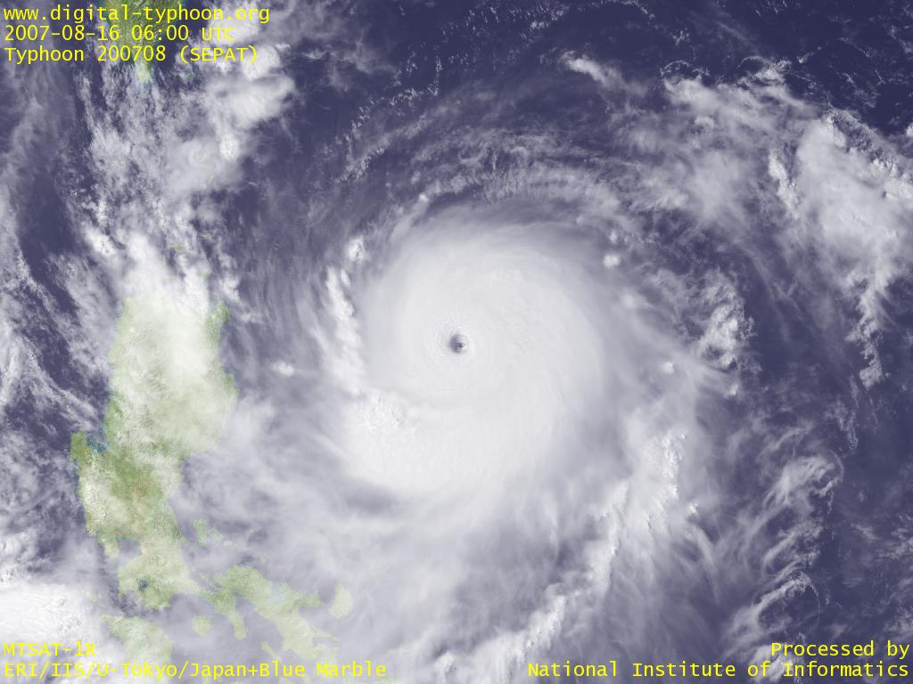
2007-08-16 19:30 JST
Typhoon SEPAT has reached the central pressure of 910hPa. This typhoon has intensified as if it was destined (?) to do so, whose development was beyond the expectation of forecasters. Images below show that the eye is small and sharp, and the surrounding eye-wall clouds are vertical and thick. The intensity of this level is hard to keep, and sometimes a typhoon got weakened by losing balance, so normally the intensity of this level can be kept for one or two days. But this typhoon is already located not so far from Sakishima Islands or Taiwan, and this is a distance that the typhoon can keep its intensity until approaching there.
The list of typhoons that had a low central pressure can be searched from "Search by the Lowest Central Pressure." It reveals that this is the 101th typhoon since 1951 that recorded the central pressure of less than 910hPa. The list reminds us of a recent destructive typhoon Typhoon MAEMI (200314) that passed near Miyakojima Island with the central pressure of 910hPa. The maximum gust is estimated to reach 90m/s in the island, and this strong winds gave huge damages across the island. This disaster clearly demonstrated how destructive a typhoon of 910hPa is.
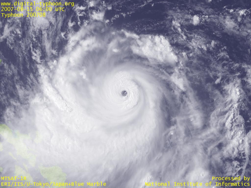
2007-08-15 19:30 JST
Typhoon SEPAT is showing steady intensification that exceeds the intensity forecast of Japan Meteorological Agency. It looks that the typhoon is, from its birth, well-balanced and moderately-sized, so it breezes through development stages without structural changes that may result in the delay of intensification. The image below shows the small eye at the center, which suggests that the typhoon is now very strong.
2007-08-13 12:15 JST
On Typhoon SEPAT, I wrote this morning that "intensification is relatively limited" but it seems that intensity forecast may be upwardly revised. The form of the typhoon on satellite images is getting organized. In any case, this typhoon is located in east of Phillipines, which is well known for the intensification of typhoons, so we need to pay attention to the latest typhoon information.
2007-08-13 09:00 JST
Typhoon SEPAT was formed in east of Philippines. Recently we have seen the successive occurrece of small typhoons, and the intensification of this typhoon is also forecast to be relatively limited.
Related Typhoon Blog Entries
- 2005 Cyclone INGRID
- Typhoon 200614 (YAGI)
- Typhoon 200505 (HAITANG)
- Typhoon 200616 (BEBINCA)
- Typhoon 200504 (NESAT)
- Typhoon 201013 (MEGI)
- Typhoon 200521 (KAI-TAK)
- Typhoon 200507 (BANYAN)
- Typhoon 200226 (PONGSONA)
- Typhoon 202204 (AERE)
|