|
2009-09-19 16:15 JST
Typhoon CHOI-WAN is now passing near Ogasawara Islands and the area is within the storm wind circle. Chichijima recorded the maximum gale of 42.9m/s at 14:56 JST. The typhoon has passed the closest point, but the area will suffer from strong winds for a while.
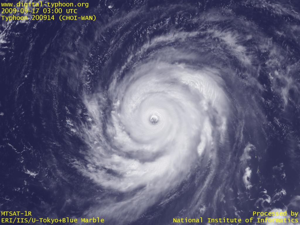
2009-09-17 22:00 JST
Typhoon CHOI-WAN's central pressure has weakened since yesterday, but the maximum wind at the center has weakened only a little, which means that the typhoon is still a very strong one. It is forecast to get closest to Ogasawara Islands tomorrow night or the day after tomorrow. The actual effect of typhoon depends on the typhoon track from now, but in any case Ogasawara Islands will have very severe weather because it is on the eastern side of the typhoon.
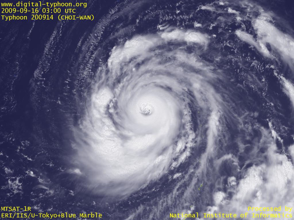
2009-09-16 20:00 JST
Typhoon CHOI-WAN is moving west in Mariana Islands keeping its very strong intensity. The image below shows that the size of the eye is larger today than yesterday, and the eyewall clouds changed from vertical clouds to sloped clouds. It seems that this change indicates the change of the status from a very tight shape to a little loose shape, but detailed wind information shows that the radius of storm wind suddenly shrunk this morning from 140NM (=260km) to 90NM (=170km). In any case, the typhoon seems to be transformed to a developing stage to a mature stage.
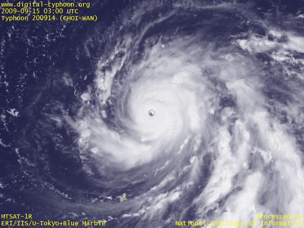
2009-09-15 21:00 JST
Typhoon CHOI-WAN has been in the process of intensification. The size grew to a large typhoon, and clouds at the core got even thicker. The eye is now clearly visible, and the typhoon is forecast to keep intensification for a while.
By the way, the typhoon track on Google Earth shows that the typhoon has passed near Alamagan Island in the north of Northern Mariana Islands. But damage in Northern Mariana Islands seems to be minor because islands in the north have very small population, if any, and the typhoon is about 200km away from more populated areas such as Saipan. The typhoon is moving slowly away but strengthening more, so the situation is that the effect of typhoon is hardly moving away.
2009-09-15 01:00 JST
Typhoon CHOI-WAN is in the process of intensification, and is moving slowly near Northern Mariana Islands. Sea surface temperature shows that this typhoon will soon go out of the area of 30 degree Celsius, but is still within the area of 29 degree Celsius, so it is expected to keep intensification. The image below illustrates, however, that this typhoon is well-balanced, but the volume of clouds is still far from a very powerful typhoon at this moment.
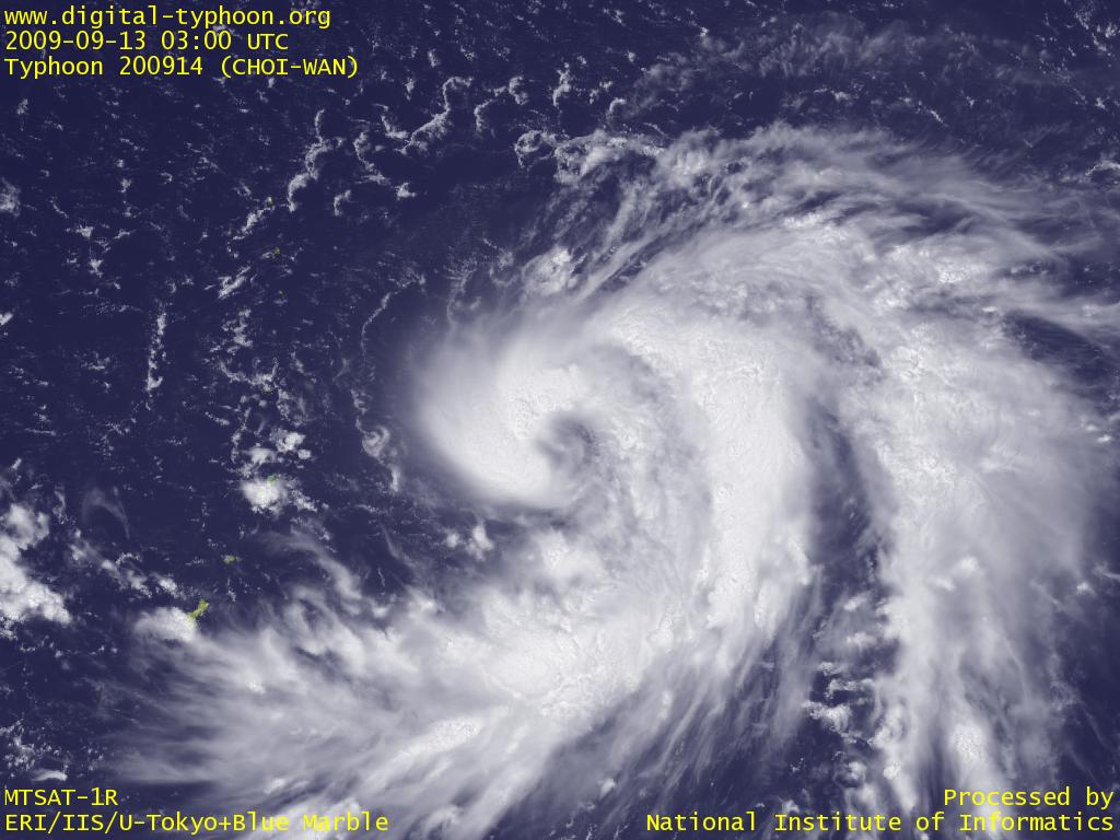
2009-09-13 22:45 JST
Typhoon CHOI-WAN may become a long-absent "full-blown" typhoon in the sense that its birthplace and its growing is authentic. Mariana Islands are known to have produced many strong typhoons, because if typhoons move westward from here, 1) it does not meet big islands that prevents its intensification, 2) it can absorb much energy for a long period from the vast areas of Pacific Ocean with warm sea surface temperature, and 3) its structure is not disturbed by complex winds because of weak winds inside the subtropical high-pressure system in the Pacific Ocean. In addition, this typhoon needs careful attention because its shape and size is well-organized and well-balanced, which indicates further intensification.
2009-09-13 08:15 JST
Typhooon CHOI-WAN was formed in Mariana Islands. It is forecast to intensify and approach Northern Mariana Islands, and will pass in north of Saipan.
Related Typhoon Blog Entries
- Typhoon 200419 (SARIKA)
- Typhoon 200422 (MA-ON)
- Typhoon 200406 (DIANMU)
- Typhoon 200813 (SINLAKU)
- Typhoon 200715 (KROSA)
- Typhoon 200424 (NOCK-TEN)
- Typhoon 200417 (AERE)
- Typhoon 201210 (DAMREY)
- Typhoon 200815 (JANGMI)
- Typhoon 200503 (SONCA)
|