|
2006-09-29 23:45 JST
2006-09-15 08:15 JST
Typhoon IOKE has forced people in Wake Islands to evacuate, and the initial assessment by the Air Force revealed that about 70% of the building was damaged by the typhoon. Then, how is Minami Torishima, another island of full evacuation?
2006-09-08 08:30 JST
Typhoon IOKE was originally born in south of Hawaii Islands, slowly moved westward, and managed to pass the 150E degree, but then turn to north without coming close to Japan. Its travel was so long even to pass the 50N degree, so the length of movement from a hurricane to a typhoon is more than 10000km in total, which is a rarely long. The lifetime also reached 17.8 days, which is one of the longest in history of long-life typhoons ( the definition of life period). In short, this is a record-breaking typhoon in many respects.
2006-09-03 21:30 JST
Typhoon IOKE is nearing the 150E degree, and this typhoon is beginning to turn northward, as many previous typhoons that took similar tracks did near this longitude. The typhoon is also gradually weakening since it is difficult to keep this intensity at this latitude, so the probability of the typhoon giving some effects on Japan is decreasing. But the effect is of course significant in the sea, so it is still important to keep watching the latest typhoon information from Japan Meteorological Agency.
By the way, this typhoon has kept "Category 4" through 0600 UTC 2 September by a categorization in the US standard. It amounts to the period of 8 days 19 hours since 1100 UTC 24 August for the typhoon to keep an intensity greater than Category 4 (including Category 5). It was suggested that this period may be the longest record in the (modern) history of worldwide tropical cyclones (unconfirmed information).
It is usually hard for a typhoon to keep this intensity for the long period of time because the typhoon may make landfall somewhere as it keep moving, or it may move too north to keep a strong intensity, with exceptions like Typhoon 200318 making merry-go-round-like track in the middle of the ocean. The unusual longevity of Typhoon IOKE may be attributed to two reasons. The first reason is the birthplace, which was in south of Hawaii Islands, so a subsequent westward movement across the Pacific Ocean resulted in a landfall on a large land fairly unlikely. The second reason is the track, which was like rolling north and south for a few days, so its total movement toward north had been very slow.
2006-09-02 08:15 JST
Typhoon IOKE started to lose its well-formed shape with its eye less clearly visible. In comparison to previous hours, good conditions for intensification are gradually lost, but it is still likely that the typhoon will keep its intensity if good conditions for typhoons, such as small wind shear and high sea surface temperature, are met, and Japan Meteorological Agency is expecting re-intensification in the coming hours. Another caution should be paid on the enlargement of the 50kt wind area, which may be better interpreted as the onset of the enlargement of the typhoon.
2006-09-01 18:00 JST
Typhoon IOKE passed about 30km off the coast of Wake Island around 0900 UTC 31 August. The real-time data has been received intermittently, but it recorded the minimum pressure of 934hPa.
After the evacuation at Wake Island, another evacuation was carried out at Minami-Torishima (Marcus Island) (Wikipedia Minami Torishima), which is right on the forecast track. According to the press release (in Japanese) from Japan Meteorological Agency, about 40 people staying in the island have flown away from the island this afternoon. Asahi Shimbun says that this is the first time for the people of the island to evacuate from the island because of the approach of a typhoon since the return of the island from the US to Japan on 1968, so this fact also suggests that this typhoon is an unusual one.
You can search the list of typhoons that approached Minami Torishima from Search by Place (Latitude / Longitude) at the link "Within 150km around Minami Tori-shima." In addition, you can search the extreme observations in history at Minami Torishima at Data Until Yesterday (Statistics) (in Japanese).
Comparison of two data sources shows that strong typhoons that hit Minami Torishima recently are Typhoon 196913 (Max. Wind 43.3m/s, Max. Gust 58.2m/s), Typhoon 197717 (Max. Wind 37.6m/s, Max. Gust 57.2m/s), Typhoon 199720 (Max. Wind 34.5m/s, Max. Gust 47.6m/s). But this time Japan Meteorological Agency decided evacuation for the first time, probably because they thought this typhoon will keep an exceptionally strong intensity in comparison to those previous typhoons.
By the way, today is a day for disaster preparedness in Japan. The day in the last year was a period when the causes of catastrophe of Hurricane Katrina was beginning to be revealed. Luckily enough, this year Atlantic basin has been relatively calm.
2006-08-31 12:30 JST
Typhoon IOKE has eventually appeared in the right-hand edge of Typhoon Front. If you switch the screen to satellite imagery, you can see the eye and sprial clouds sorrounding the core.
According to data from NOAA at Real-time meteorological observations at Wake Island, expected to be hit directly by the typhoon this evening, the barometric pressure is rapidly decreasing, while the wind speed already exceeded 25m/s (gusts over 30m/s).
2006-08-30 19:30 JST
Typhoon IOKE shows a typical shape of an intense typhoon, which is a very clear eye with thick clouds surrounding the eye in a well-balanced rounded shape. Central Pacific Hurricane Center has already issued a comment that Hurricane IOKE recorded the lowest sea level pressure, and the third strongest winds since 1960s in this area, but it looks like the typhoon has further intensified. Daily sea surface pressure indicates that the typhoon will move over high sea surface temperature for the moment, so it will basically keep its intensity at least for a day or two, according to Japan Meteorological Agency.
A place that will be damaged by this typhoon is Wake Island. If the typhoon will keep its current direction, this island will be hit directly by the monster typhoon in about one day. According to Wikipedia, Wake Island (or Wake Atoll) is a small and flat island with its area of about 6.5km^2 and the highest point of 6m. But it is forecast that this island will see the storm surge of as high as 12m, so it is expected that the island will be submerged by the storm surge. Of course there is no place in the island to escape from the storm, so all the people (mainly military personnel) has already evacuated from Wake to Oahu Island.
If you look at typhoon clouds on Google Earth Version(*1), the outer band of the typhoon clouds is beginning to come over Wake Island, so the island will see fierce storms from now. Meteorological observation at the site is good information as a reference, but it seems that the observation has already stopped.
(*1)If you remove the display of typhoon clouds, you can see what kind of anisland Wake is.
2006-08-29 21:30 JST
Typhoon IOKE is still keeping a strong intensity, but the typhoon is now gaining a northward movement, so it may be going to be difficult to keep this intensity if the typhoon will keep increasing its latitude in position.
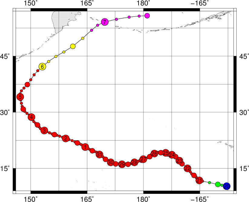
By the way, the organization in charge of observing hurricanes was used to be Central Pacific Hurricane Center (CPHC) in Honolulu when Typhoon IOKE was Hurricane IOKE, and the figure below is a tracking chart of both a typhoon and a hurricane made by connecting data from CPHC and JMA. If you study the track information in this way, you should add 3039km to "length of movement" and 168 hours to "lifetime."
2006-08-28 21:30 JST
Typhoon IOKE is attracting people's attention as an unusual typhoon that was changed from a hurricane. A natural question here is how many such typhoons we had in the past. By referring to the best track data by Japan Meteorological Agency, we count the number of typhoons that have their origins in the east of the 180 degree line, at least as a tropical depression.
First you access Search by Map and set latitude as 14+-14, longitude as 181+-1, categories as 2, 3, 4, 5, 7, 9 (except for 6), and search top 50 typhoons. Then we have 26 typhoons as a result, but after investigation you will find that one of them is actually a typhoon born in the eastern longitude and moved to the western longitude, so in conclusion we have 25 typhoons that have their origins in the western longitude. In particular, Typhoon IOKE has the strongest intensity in history when entered into the eastern longitude.
Also note that if you observe the tracking chart drawn using "Search by Map," most of the typhoons turned from westward to northward and eastward in the east of the 150E degree line, and moved away from Japan. This typhoon is forecast to move at least near the 155E degree line, according to JTWC, but how the typhoon will move afterward is still unknown.
2006-08-27 17:00 JST
Typhoon IOKE became a typhoon from a hurricane after reaching the line of 180 degree east (west). This name is not an Asian name of a typhoon, but a hurricane name for the Central Pacific basin. As may be expected, there is only one typhoon Typhoon 199719 in the past 50 years to reach Japan's main islands from this area after traveling as far as 6000 km, but let's pay attention to this typhoon as the first typhoon in four years that crossed the International Date Line since the 2002 typhoon season, or Typhoon 200217, and Typhoon 200224.
By the way, this hurricane has already been captured since one week ago on the Himawari globe image (2048x2048) accessible from the top page. On the following animation, you can see Hawaii Island on the upper right corner, and Hawaii islands continuing to the left, and you can observe that a vortex of clouds that appeared in south of Hawaii Islands are gradually evolving to become a strong hurricane.
Links
Related Typhoon Blog Entries
- Typhoon 201313 (PEWA)
- Typhoon 202308 (DORA)
- Cyclone ZOE
- Typhoon 200710 (DANAS)
- Typhoon 201010 (MERANTI)
- Typhoon 201413 (GENEVIEVE)
- Typhoon 200601 (CHANCHU)
- Typhoon 200614 (YAGI)
- Typhoon 200315 (CHOI-WAN)
- Typhoon 201527 (MELOR)
|